Israel feels exposed as US drops satellite-imaging cap
JERUSALEM: An Israeli official flagged a possible security risk on Monday following a U.S. move to allow American providers to sell clearer satellite images of Israel and the Palestinian territories. Under a 1997 U.S. regulation known as the Kyl-Bingaman Amendment, satellite images of Israel and the Palestinian territories used in services like Google Earth could show items no smaller than 2 metres (6.56 ft) across. The curb, Israel had argued, would help prevent enemies using public-domain information to spy on its sensitive sites. But the U.S. Commercial Remote Sensing Regulatory Affairs Office said on June 25 it would allow enhanced resolutions of 0.4 metre. In a statement, the agency said “a number of foreign sources” are already producing and disseminating sub-2 m. imagery of Israel. Amnon Harari, head of space programmes at Israel’s Defence Ministry, said he believed the move was designed to ease international competition for US commercial satellites, adding: “I don’t think they (Americans) asked us” in advance.


-
 Alix Earle And Tom Brady’s Relationship Status Revealed After Cosy Super Bowl 2026 Outing
 -
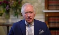 Why King Charles Has ‘no Choice’ Over Andrew Problem
 -
 Shamed Andrew Wants ‘grand Coffin’ Despite Tainting Nation
 -
 Keke Palmer Reveals How Motherhood Prepared Her For 'The Burbs' Role
 -
 King Charles Charms Crowds During Lancashire Tour
 -
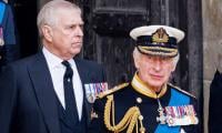 ‘Disgraced’ Andrew Still Has Power To Shake King Charles’ Reign: Expert
 -
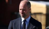 Why Prince William Ground Breaking Saudi Tour Is Important
 -
 AOC Blasts Jake Paul Over Bad Bunny Slight: 'He Makes You Look Small'
 -
 At Least 53 Dead After Migrant Boat Capsizes Off Libya
 -
 'God Of War' Announces Casting Major Key Role In Prime Video Show
 -
 Real Reason Prince William, Kate Broke Silence On Andrew Scandal Revealed
 -
 Drew Barrymore Responds To 'Charlie's Angels' Costar's Comments About Her
 -
 Shakira Slips Hard On Stage During Life Show
 -
 King Charles Speaks Out Over Andrew's Scandal: 'Stand Ready To Help Police'
 -
 Dax Shepard Recalls Horrifying Accident That Almost Killed Him
 -
 Logan Paul's Bodyguard Hits Fan On Super Bowl Day