Australia’s north braces for Tropical Cyclone Megan
Australia is experiencing an El Nino weather event
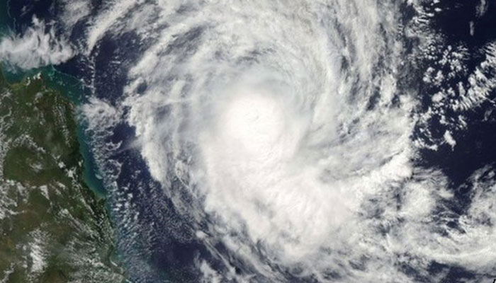
SYDNEY: Residents in parts of Australia’s Northern Territory and Queensland state were urged on Sunday to prepare for a tropical cyclone that is forecast to make landfall in coming days.
Megan, a category two cyclone sitting in the Gulf of Carpentaria with wind gusts up to 155 kph , was expected to cross the coast on Monday or early Tuesday morning as a “severe tropical cyclone”, the nation’s weather forecaster said.
Australia is experiencing an El Nino weather event, now easing, and typically associated with extreme phenomena such as cyclones, wildfires, droughts and heatwaves.
Gales with damaging wind gusts of 110 kph were already sweeping remote Groote Eylandt, off Northern Territory’s Arnhem Land, about 653 km east of territory capital Darwin, the forecaster said.
It was likely Megan would intensify to category three later on Sunday, the weather forecaster said, urging those in the warning zone to prepare their properties for strong winds.
Category two cyclones are three rungs away from the most dangerous and can cause significant damage to trees, caravans, and crops, and break boats from their moorings. Category three cyclones typically cause more severe damage to houses, shops and other buildings.


-
 Tucker Carlson Says Passport Seized, Staff Member Questioned At Israel Airport
 -
 Taylor Swift Made Sure Jodie Turner-Smith's Little Girl Had A Special Day On 'Opalite' Music Video Set
 -
 Eric Dane Says Touching Goodbye To Daughters Billie And Georgia In New Netflix Documentary
 -
 Channing Tatum Reveals What He Told Daughter After Violent Incident At School
 -
 King Charles Lands In The Line Of Fire Because Of Andrew Mountbatten-Windsor
 -
 Denise Richards Doubles Down On Abuse Claims Against Ex Husband Aaron Phypers Amid Show Return
 -
 Russia Set To Block Overseas Crypto Exchanges In Sweeping Crackdown
 -
 Gwyneth Paltrow Reveals Deep Personal Connection With Kate Hudson
 -
 Prince Harry, Meghan Markle’s Game Plan For Beatrice, Eugenie: ‘Extra Popcorn For This Disaster’
 -
 OpenAI To Rollout AI Powered Smart Speakers By 2027
 -
 Is Dakota Johnsons Dating Younger Pop Star After Breakup With Coldplay Frontman Chris Martin?
 -
 Hilary Duff Tears Up Talking About Estranged Sister Haylie Duff
 -
 US Supreme Court Strikes Down Trump’s Global Tariffs As 'unlawful'
 -
 Kelly Clarkson Explains Decision To Quit 'The Kelly Clarkson Show'
 -
 Inside Hilary Duff's Supportive Marriage With Husband Matthew Koma Amid New Album Release
 -
 Daniel Radcliffe Admits To Being Self Conscious While Filming 'Harry Potter' In Late Teens