Biparjoy: Up to 100mm rain expected in Karachi
300mm to 400mm of rain is expected in Thatta, Sajawal, and Badin
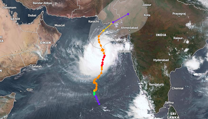
The Pakistan Meteorological Department (PMD) Monday warned that due to the storm surge in the Arabian Sea, 300mm to 400mm of rain is expected in Thatta, Sajawal, and Badin, while up to 100 mm is expected in Karachi.
The cyclone will pass between Keti Bandar and Indian Gujarat on the afternoon of June 15, causing waves of 10 to 12 feet and gusts of up to 120 kilometres per hour at the Pakistani seaport.
Rain and strong winds are forecast to begin tomorrow in Karachi, Hyderabad, Thatta, and Mirpurkhas.
In Karachi, billboards have not yet been removed from the buildings. Meanwhile, In view of the storm, the Seaview road was closed, with access to the beach prohibited from a local restaurant to Khayaban-e-Ittihad.
Mercury to scorch Karachi
With the cyclone inching closer to Karachi, mercury is likely to rise to 41°C. Biparjoy is at least 600 kilometers south of Karachi, and under its influence, the weather is likely to remain humid and hot in the port city, where the mercury touched 34°C this morning.
The Met Office has, meanwhile, forecast that the maximum temperature today is likely to be 39°C to 41°C, which may touch 45°C, with a minimum temperature of 30°C.
In Karachi, the wind speed is 18 kilometers per hour from the southeast direction, with a humidity ratio of 41%.
According to PMD, the cyclone has been moving northwards for the past 12 hours, which is 580 km south of Thatta. By June 14, the cyclone will move northwards, while on the afternoon of June 15, it will cross southeast Sindh and Indian Gujarat.
According to Sindh Chief Meteorologist Sardar Sarfaraz, the intensity of storm is increasing due to climate change; however, it will take three to four days for it to subside once it hits the region.


-
 Security forces gun down 30 terrorists in multiple IBOs in KP: ISPR
 -
 MQM-P calls for new province in Sindh
 -
 US report validates Pakistan military edge over India: PM
 -
 Banned TTP poses serious threat to Pakistan security: UNSC panel
 -
 CM Afridi clarifies remarks on by-poll after ECP requests army deployment
 -
 Dubai sees 3.2m Pakistani passengers in 2025 as airport sets new milestone
 -
 Security forces kill 23 Indian proxy terrorists in KP's Kurram
 -
 Pakistan to construct island to boost oil exploration: report