Polar Vortex enters final ‘seasonal’ phase: Rare shift signals winter weather risks into April
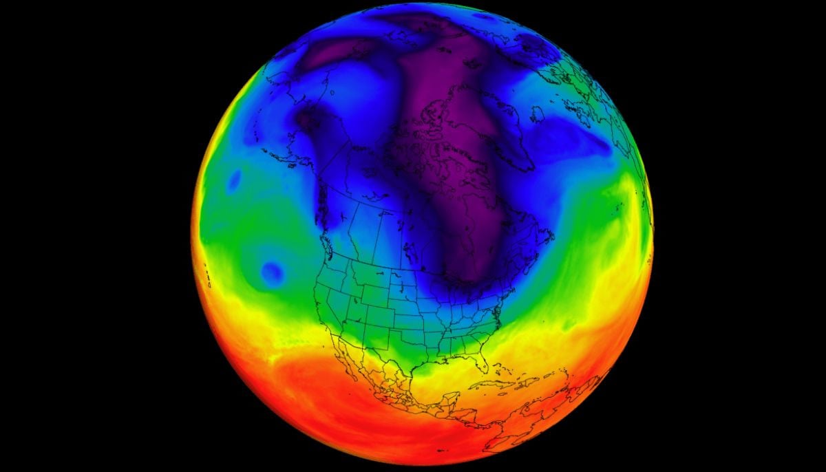
A residual Polar Vortex core remains active in the lower atmosphere, centered over North America and eastern Canada
A rare extension of the Polar Vortex core is currently disrupting the seasonal transition across the Northern Hemisphere. As April begins, the stratospheric Polar Vortex is entering its final seasonal phase. The high-altitude circulation is dispersing, releasing the lower-level Polar Vortex core and bringing another round of weather impacts across North America and Europe in April 2026.
A fragmented piece of the Polar Vortex remains active in the lower atmosphere, currently anchored over North America and eastern Canada. This left-over core is responsible for funneling Arctic air southward, keeping temperatures below normal and maintaining a high risk of late-season snowfall across the United States. The weather pattern is being driven by the final downward waves of a massive stratospheric collapse that began earlier this year. As the season attempts to transition, the atmosphere is undergoing a reset where the traditional winter circulation is breaking down in favor of spring dynamics.
The mechanics of the Polar Vertex
The Polar Vortex is a massive, circular weather system that acts as a wall, trapping freezing Arctic air over the poles. It spans two layers: the stratosphere (high altitude) and the troposphere (lower surface level). The system is powered by the extreme temperature difference between the cold Arctic and the warm tropics. As the sun returns to the North Pole in spring, this temperature gap ultimately closes, causing the engine to fail and the vortex to dissolve.
Current regional impacts
A lingering vortex core over eastern Canada is pulling northerly A lingering vortex core Eastern Canada is pulling northerly Arctic air down into the northern and eastern United States, resulting in below-normal temperatures for early April. While the North stays cold, a warmer westerly and southerly flow is simultaneously spreading across the central and southern United States, creating a sharp temperature contrast across the country.
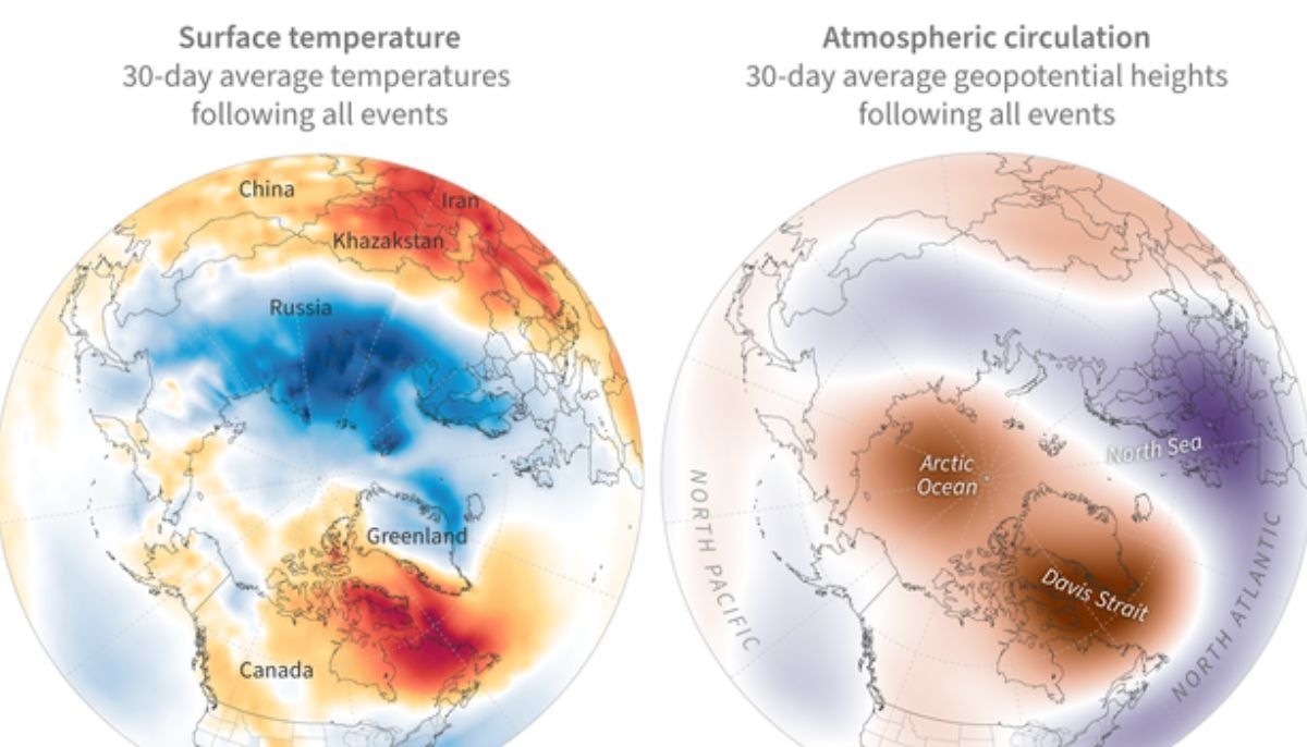
Most of mainland Europe is seeing a cooler tendency due to a low-pressure pattern pulling in northern air, though the far north and eastern regions may experience brief warm southerly flows. The forecasting model suggests a major transition toward a blocking pattern in late April. This represents the final stage of the atmosphere resetting for the remainder of the spring. Experts note that while specific daily temperatures for late April are hard to pin down, the broad pressure trends indicate that the atmospheric transition will remain active and somewhat unpredictable through the end of the month.

-
 Biden calls out Trump’s ‘vanity projects’ at Maryland Democratic Gala—Here’s why
 -
 Pima County Sheriff responds to new claims in Nancy Guthrie case
 -
 Mayor Mamdani jumps into NYC pool to revive old tradition
 -
 Trump’s Gaza Board of Peace seeks to grant itself total immunity and free use of property: Here’s why
-
 Scientists found 'super-puff' planets 1,110 light-years away
 -
 Scientists find ancient microbial life in places it shouldn't exist
 -
 Why Marijuana is suddenly sending thousands of dogs to hospitals in US?
 -
 36 years on, Hubble shows how stars actually change over time
 -
 Hidden magma beneath Mars? Scientists' 'unexpected' discovery raises new questions about alien life
 -
 Rare 3,200-year-old coral blue hole discovered in South China Sea
 -
 What happens at black hole’s event horizon? Scientists find the first-ever clue
 -
 Scientists discover evidence of fires used by humans 1.8 million years ago
-
 Did NASA just uncover evidence of ancient life on Mars? Key discoveries explained
 -
Four powerful earthquakes strike three continents within hours: Scientific link or coincidence?
-
Mysterious interstellar comet passing our solar system may be 12 billion years old, scientists say
-
When do we really become adults? Science has an answer


