Cyclone Biparjoy intensifies, inches closer to Pakistan's coastline
Cyclone is 770 kilometres away from Karachi and 750 kilometres far from the south of Thatta, chief meteorologist says
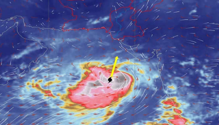
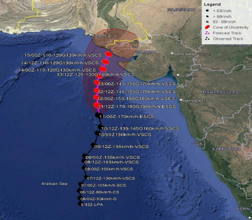
The Very Severe Cyclonic Storm (VSCS), Biparjoy, in the Arabian Sea has intensified and turned into an Extremely Severe Cyclonic Storm (ESCS) moving northward in the last 12 hours, the Pakistan Meteorological Department (PMD) said on Sunday.
The current position of the cyclone is approximately 760 kilometres south of Karachi, 740 kilometers south of Thatta, and 840 kilometres southeast of Ormara, with coordinates near latitude 18.1°N and longitude 67.5°E.
Dr Sardar Sarfaraz, the PMD chief meteorologist in Sindh, this cyclone system will continue to move northwards. The wind speed at the centre’s system is between 150 to 160 kilometres, while waves are 30 to 40 feet high at the centre and around the system.
"The favourable environmental conditions (sea surface temperature of 30-32°C, low vertical wind shear and upper-level divergence) are supporting the system to maintain its intensity," the PMD statement read.
The statement further mentioned that under the existing upper-level steering winds, the ESCS Biparjoy is most likely to track further northward until the June 14 morning, then recurve northeastward and cross between Keti Bandar (Southeast Sindh) and Indian Gujarat coast on June 15 afternoon as a VSCS. PMD’s cyclone warning centre, Karachi is continuously monitoring the system and will issue update accordingly, it added.
The weather in the port city will likely fluctuate between 35°C to 37°C, while the minimum temperature will be 29°C. However, the mercury is expected to rise up to 40°C on Monday.
At present, the level of humidity in the city’s air is at 76%, while winds are blowing at a speed of five kilometres. Overall the weather is expected to remain hot and humid in the next 24 hours.
There is a chance of rain with strong winds and thundershowers in Southeast Sindh, the Met Office said. During this time, winds can blow at a speed of 60 to 80km per hour.
Owing to the cyclone's threat, the Karachi administration imposed a ban on entering the city's beaches for fishing, swimming, sailing and bathing effective from today (June 11) till the "end of the storm."
The decision was taken to avoid any untoward incident of shipwreck or drowning. However, despite the ban, people are still fishing at the beach and fishermen were also present in the sea with their boats.
Meanwhile, fishermen of Ormara have also been advised to stay away from the sea from today till June 17, while citizens have also been prohibited from picnicking near the sea, the provincial fisheries department said.
Possible impacts
- With its probable approach to the southeast Sindh coast, widespread wind-dust/thunderstorm rain with some very heavy/extremely heavy falls accompanied with squally winds of 80-100 kilometres per hour likely in Thatta, Sujawal, Badin, Tharparker and Umerkot districts during June 13-17.
- Dust/thunderstorm-rain with few heavy falls and accompanied by squally winds of 60-80 kilometres per hour likely in Karachi, Hyderabad, Tando Muhammad Khan, Tando Allayar, Mirpurkhas districts from June 13 and 14 to 16.
- Squally (high-intensity) winds may cause damage to loose and vulnerable structures (katcha houses).
- A storm surge of 3-3.5 meters (8-12 feet) is expected at the land falling point (Keti Bandar and around).
- Fishermen are advised not to venture into the open sea till the system is over by 17 June, as the Arabian Sea conditions may get very rough/high accompanied by high tides along the coast.
Flights affected
Flight operations around the country remain affected due to the bad weather across cities.
The Civil Aviation Authority (CAA), in a statement, said that flight PK798 from Toronto to Lahore was diverted to Islamabad. Three flights PK262 from Dubai to Islamabad, PK760 from Jeddah to Lahore and an international flight coming from Dubai to Islamabad were diverted to Multan.
Flight PK747 from Lahore to Madinah, as per the CAA, was delayed by three hours and 20 minutes, while an international flight from Lahore to Abu Dhabi was delayed by three hours and five minutes. Meanwhile, flight PK406 from Karachi to Lahore was delayed by 35 minutes.
A private airline's flight from Lahore to Jeddah was cancelled due to operational reasons. Another private airline flight from Lahore to Karachi got delayed by two hours 25 minutes at Kashkar, the CAA stated.
Flight PK186 from Sharjah to Lahore was diverted to Faisalabad and a private flight from Karachi to Lahore was diverted to Islamabad, the CAA mentioned.
Power supply in Multan remained suspended for three hours in New Multan's Block T after a storm.
Cyclone to affect south, southeastern part of Sindh till June 13: NDMA
According to the National Disaster Management Authority (NDMA) spokesperson, the cyclone is likely to affect the south and southeastern part of Sindh till June 13.
“The cyclone can cause strong winds and torrential rains in coastal areas,” the spokesperson said.
He added that the PMD and Provincial Disaster Management Authorities (PDMA) are in touch with the relevant institutions.
“All institutions are instructed to be ready to deal with any kind of emergency,” the NDMA representative said, urging people to avoid going to the beach for sightseeing and fishermen to avoid going into the open sea.
“Follow the instructions of the local administration in any emergency situation,” the spokesperson said.


-
 Security forces gun down 30 terrorists in multiple IBOs in KP: ISPR
 -
 MQM-P calls for new province in Sindh
 -
 US report validates Pakistan military edge over India: PM
 -
 Banned TTP poses serious threat to Pakistan security: UNSC panel
 -
 CM Afridi clarifies remarks on by-poll after ECP requests army deployment
 -
 Dubai sees 3.2m Pakistani passengers in 2025 as airport sets new milestone
 -
 Security forces kill 23 Indian proxy terrorists in KP's Kurram
 -
 Pakistan to construct island to boost oil exploration: report