7.0-magnitude quake hits eastern Indonesia, tsunami warning lifted
Indonesia's earthquake magnitude was around 7.0, which forced panicked residents to run into the streets
An offshore earthquake in Indonesia with a magnitude of 7.0 hit near eastern Maluku islands on Wednesday, forcing panicked residents to run into the streets and briefly triggering a tsunami warning.
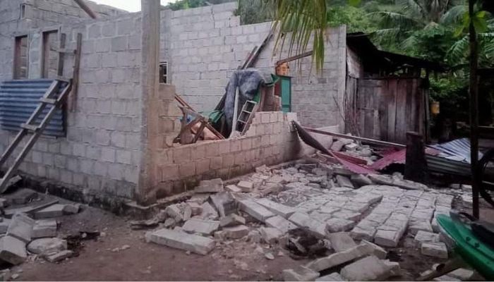
There were no immediate reports of casualties but light damage was reported on at least one island.
The epicentre of the tremor was located 150 kilometres (93 miles) northwest of the eastern Indonesian island of Halmahera, at a depth of 48 kilometres, the US Geological Survey (USGS) reported.
The undersea quake occurred around 13:06pm local time (0606 GMT) off the coast of Sulawesi island, shaking nearby islands and sending some residents into the streets.
"The quake was felt around 15-20 seconds. The shakings were quite long," an AFP journalist on Morotai island in the Maluku archipelago said.
"Some people went outside because they were afraid of buildings collapsing."
Abner Manery, the head of the North Halmahera disaster mitigation agency, said some houses on Morotai were damaged.
A resident described the moment the quake shook the island.
"When it hit, we rushed outside, slightly panicked," Rizkal Fuadsamlan, 29, told AFP.
The NWS Pacific Tsunami Warning Center in Hawaii said in an updated warning the tsunami threat had passed.
It said earlier tsunami waves could hit coastal areas around 300 kilometres from the epicentre.
The quake was also revised down from an initial magnitude of 7.2 reported by the USGS.
Indonesia's Meteorology, Climatology and Geophysics Agency (BMKG), which put the magnitude at 7.1, warned of possible aftershocks.
Daryono, the head of the agency's earthquake and tsunami centre who like many Indonesians goes by one name, said the tremor was followed by 10 aftershocks, the largest with a magnitude of 5.3.
He tweeted the quake was "triggered by (a) rock deformation in the Maluku Sea Plate".
The initial quake was felt as far away as the city of Gorontalo in northern Sulawesi, where it shook houses, and the provincial capital, Manado.
A powerful quake hit deep under the ocean in eastern Indonesia earlier this month, rattling nearby islands and damaging homes and schools.
The 7.6-magnitude quake caused roofs and walls to collapse in homes on the worst-hit Tanimbar Islands in the Maluku archipelago.
Indonesia experiences frequent seismic and volcanic activity due to its position on the Pacific "Ring of Fire", where tectonic plates collide.
A 5.6-magnitude quake hit West Java province on Indonesia's main island of Java on November 21, killing 602 people.
Most of the victims were killed when buildings collapsed or in landslides triggered by the quake. A 2018 quake and resulting tsunami on Sulawesi island killed more than 4,000 people. A major earthquake off Sumatra on December 26, 2004, set off an Indian Ocean tsunami that killed more than 230,000 people as far away as Sri Lanka, India and Thailand.
That powerful 9.1-magnitude quake triggered 100-foot waves that hit the shore of Banda Aceh on Sumatra.


-
 Jill Biden’s former husband charged with wife’s murder
 -
 Bad Bunny delivers sharp message to authorities in Super Bowl halftime show
 -
 Thai school shooting: Gunman opened fire at school in southern Thailand holding teachers, students hostage
 -
 Maxwell could get 'shot in the back of the head' if released: US congressman
 -
 New EU strategy aims to curb threat of malicious drones
 -
 Nancy Guthrie abduction: Piers Morgan reacts to 'massive breakthrough' in baffling case
 -
 Texas father guns down daughter after heated Trump argument
 -
 FAA shuts down El Paso Airport, flights suspended for 10 days: Here’s why