R3 envisaged inclusive decongestion plan for Rawalpindi: Govt flagship project in the doldrums
Rawalpindi Ring Road (R3) envisaged an elaborate decongestion plan for Rawalpindi that it has desperately needed for decades
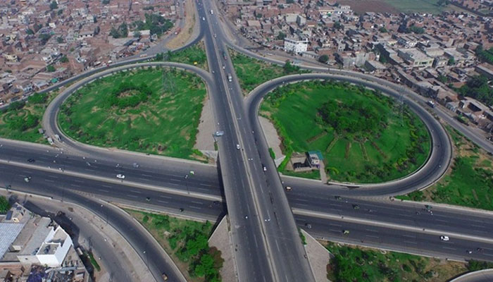
ISLAMABAD: The aborted construction of the Rawalpindi Ring Road (R3), which was to be a mega flagship project of the Pakistan Tehreek-e-Insaf (PTI) government, envisaged an elaborate decongestion plan for Rawalpindi that it has desperately needed for decades.
A comprehensive decongestion plan, a copy of which is available with The News, was professionally prepared and presented to the concerned authorities of the Punjab government that had approved it for implementation.
The plan included site selection of the proposed land uses on the R3. Its main objectives were to ease the traffic congestion in Rawalpindi and foster economic growth. According to the plan, decentralization of the city’s land uses along the R3 could help decongest it and contribute significantly to enhance the local economy of Rawalpindi.
Talking about the land use types, the plan suggested the enhancement of economic opportunity for the citizens of Rawalpindi and Islamabad and the provision of direct access to farmers. As a result, the market would provide opportunities to sell fresh products and also offer facilities for the processing and storage of commodities.
There was a plan for a truck terminal that would help ease traffic congestion by reducing overlapping and mixed transportation in the cities. It would host a refreshment centre, workshop and parking facilities. There would be a commercial hub that would ease traffic congestion in the city centre and also raise investment in infrastructure, job opportunities and tax revenues. The proposed theme parks were also proposed to increase investments in infrastructure.
All this, the plan proposed, would share the burden of health facilities available in the city. Site allocation for residential schemes and satellite towns and affordable housing would help control the urban sprawl and provide better opportunities for affordable housing. Site allocation for dumping and other solid waste management purposes would also be done.
About Rawalpindi city’s dynamics, the plan said it is the fourth ranked city in Pakistan and has an outdated master plan, which had been prepared for a period of 20 years (1996-2016). The city has uneven distribution of social/public infrastructure such as health and education.
The plan said the direction of spatial growth is from the cantonment limits in the east to west periphery towards the M2 motorway. The urban expansion is between Rakh Dhamial forest and Thalian interchange at M2, that is the Chakri Road and between Rakh Dhamial forest and Soan River i.e. Adyala Road.
From 2009 to 2019, the population density of urban settlements ranged from 1,000 to 2,000 persons per square kilometer increasing from 4% to 16% in the built-up area. Higher density shifts are towards Chakri road and Adyala road. The high density oval shaped area stretches from the middle of the cantonment to Chakri Road (at Ranial) and southwest towards Adyala road on the south, the plan said.
The analysis of Rawalpindi city over the period shows that its urban area has grown three-fold since 1995-- from 6,449 acres in 1995 to 21,217 acres in 2015 along with the expansion of the overall city by 27% in total from 76,490 acres in 1995 to 104,793 in 2015.
The plan noted abnormal trends in residential and commercial land uses and said the commercial area is out of the sustainable limit range i.e. 6.47% which may lie within 1-2% of the total city area.
It said there is a window of opportunity due to the availability of vast vacant land and low concentration of industrial land uses along the R3, and suggested site selection parameters taking in view the business proximity to determine the threshold population; local road capacity and connectivity; preservation of natural resources such as water bodies and forests; site coverage (vacant, agriculture, barren); availability of basic facilities for specific land use; availability of land for future development; and regional connectivity.
The plan took into consideration different factors like sudden vehicle breakdown due to poor vehicle conditions, the most frequent being the tyre burst and axle break; major land use changes without considering their impacts on transport, the commercialization policy being one example; lack of parks and ride facilities for the heavy traffic; poor road surface conditions, poor quality of pavements, speed bumps, etc.; poor observance and enforcement of traffic laws at sensitive locations; poor control at locations of traffic conflicts; insufficient parking capacity specially during no-entry hours; and stoppage by police for no reason.
It noted the effects of traffic congestion by incidents like reduced road capacity through blockage of sufficient road area for many hours, resulting in bottlenecks and frequent traffic jams especially at the EME stop, on IJ Principal Road, Westridge Carriage factory, Mandi More, Faizabad etc.
The plan said the policy shifts had created imbalance between travel demand and road capacity; increased the entry of commercial vehicles into Rawalpindi city; led to illegal on-street parking; cut down effective road capacity; slowed down the traffic; affected traffic flows resulting in traffic accidents and delays; resulted in poor utilization of road capacity; created physical bottlenecks, U-turns for buses and other commercial vehicles.
The Capital Development Authority stressed that the extension of the R3 to the proposed Margalla Avenue should be in line with the Master Plan of Islamabad. Another government department emphasised that more land should be allocated for grain and vegetable markets and workshops and warehouses.
The Strategic Plan Division urged revision of the location of the industrial zone proposed near the Hakla interchange. According to an official document, the Project Review Committee (PRC) of the Private Partnership Policy (PPP) and Monitoring Board headed by Dr Salman Shah, advisor to the Chief Minister on Economic Affairs, also in its seventh and eighth meetings on Aug 20 and 22, 2020 held that the R3 project needs to cater for the development needs of Rawalpindi city for the next 20 years besides creating economic activity. Therefore, it is also to be noted that the previous alignment could be termed a partial bypass as it started from one point on a road and connected to another road while a true bypass connects two points at the same road diverting traffic from the busier section. Hence, it neither fully addressed the decongestion problem nor development needs as envisaged in the seventh and eighth meetings of the PRC.


-
 King Charles Plans On Grandson Prince Archie's Birthday
 -
 Kyle Richards Drops Big Dating Update
 -
 Andrew Mountbatten Windsor Steps Out After Weeks Of Silence
 -
 'Friends' Star Lisa Kudrow Sparks Debate With Blunt '90s Comments
 -
 Princess Eugenie's Marriage Under Pressure As Epstein Scandal Deepens
 -
 Sources Exposes Why Not Everything Is As It Seems In Princess Beatrice’s Home
 -
 Inside ‘separate Lives’ Of Meghan Markle, Prince Harry: 'The Stress Is Feeding Into Their Frustration'
 -
 Sosie Bacon Reveals What It's Really Like Working With Famous Parents
 -
 Prince William Sends Clear Message Ahead Of Major Royal Duty
 -
 Vin Diesel Breaks Hearts With Emotional Tribute To Paul Walker
 -
 Princess Eugenie’s Husband Edoardo Mapelli Mozzi Starts To ‘pull Away’ As His Business Fears Mount
 -
 'Harry Potter' Star Paapa Essiedu's Dream Role Turns To Terror As He Receives Death Threats
 -
 A Smarter Approach To Eating: Why Isn't Calorie Counting Enough?
 -
 Rachael Leigh Cook Opens Up About 'Josie And The Pussycats' Revival After 25 Years
 -
 Universe Collision Theory Is Back In Spotlight After A New Discovery: Here’s Why
 -
 Tencent Unveils OpenClaw AI Inside WeChat As China’s Tech Battle Intensifies