Facebook launches three maps for health organizations dealing with health emergencies
Facebook launches three maps for health organizations dealing with health emergencies
Facebook has launched three types of maps that will help non-profit organizations and universities working in public health get ahead of disease outbreaks and reach vulnerable communities more effectively.
The maps we’re introducing -- population density maps complete with demographic estimates, movement maps and network coverage maps -- will help different health sector entities better understand where people live, how they are moving and whether they have connectivity. All of these maps, when combined with information from health systems, can improve the way organizations deliver supplies and respond to outbreaks.
“Epidemics pose a growing threat to lives and livelihoods,” said Vanessa Candeias, Head of Shaping the Future of Health and Healthcare at the World Economic Forum. “Mitigating their risk and impact requires every tool in the toolbox.”
Some of Facebook’s initial partners for this effort, include: Direct Relief, FHI360, Harvard School of Public Health, the Institute for Health Metrics Evaluation at the University of Washington, International Medical Corps, the London School of Hygiene & Tropical Medicine, Malaria Atlas Project, the MRC Centre for Global Infectious Disease Analysis at Imperial College London, Northeastern University, UNICEF, Wadhwani AI, the World Bank, and the World Economic Forum.
Two years ago, Facebook began working with Columbia University to use satellite imagery and census data to build the world's most detailed population maps to improve connectivity projects. After working with groups such as the American Red Cross and Missing Maps project, Facebook realized these maps could also have profound applications in public health.
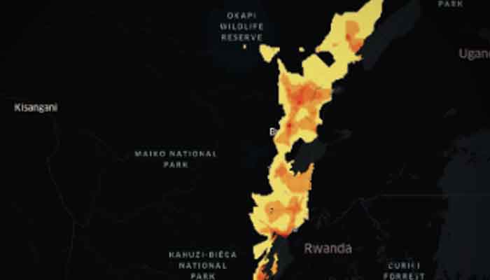
Today, we're releasing high-resolution maps that estimate not only the number of people living within 30-meter grid tiles, but also provide insights on demographics, including the number of children under five, the number of women of reproductive age, as well as young and elderly populations, at unprecedentedly high resolutions. These maps aren't built using Facebook data and instead rely on combining the power of machine vision AI with satellite imagery and census information. By combining these publicly and commercially available datasets with Facebook’s AI capabilities, we have created population maps that are three times more detailed than any other source.
Health organizations are already using this information to allocate resources to the areas where intended beneficiaries live, like in Malawi, where these maps helped the American Red Cross and the Missing Maps project identify areas with and without concentrations of people so they could deploy 3,000 health workers to deliver vaccination messaging more efficiently during a measles campaign.
Movement Maps
Public health officials often have challenges predicting where disease outbreaks, like malaria or cholera, will strike. However, cutting-edge research has found that pairing health system information with data on human mobility can yield valuable insights about diseases spread by human-to-human contact.
“Population movements are crucial for the spread of many infections - from influenza to measles, said Dr Adam Kucharski, Assistant Professor in Mathematical Modeling at the London School of Hygiene & Tropical Medicine. “But historically it’s been very difficult for disease researchers to get information on these movement patterns.”
The movement maps aggregate information from people who are using Facebook on their mobile phones with Location Services enabled, providing real-time snapshots into mobility patterns. Partner organizations can combine this data with information on disease cases to glean insights about where the next case of cholera or drug-resistant malaria is likely to occur. The improved insights from these forecasting models allow health systems to get ahead of an outbreak by prepositioning treatments where they’re likely to be needed most.
“This kind of data can be integrated into our epidemiological models to help us estimate how quickly a disease might spread, and where to put resources to contain it,” said Caroline Buckee, Associate Professor of Epidemiology at Harvard TH Chan School of Public Health.
Network Coverage Maps
Over the past decade, the increased availability of mobile health technologies has dramatically expanded access to health information. However, many countries still have areas with little or no access to the internet. Meanwhile, public health officials have limited resources to conduct house-to-house visits, as well as limited information on whether target populations can be reached digitally.
Because the majority of people use Facebook on mobile phones that rely on cellular networks, Facebook can create real-time maps that show health organizations whether people can be reached with an online message in advance of activities like vaccination days or bed net distributions. This allows public health teams to prioritize where other forms of communication are required, reaching the maximum number of people at the lowest possible cost.
It is hoped that these Disease Prevention Maps are a valuable resource for public health organizations and that this work helps improve effective health service delivery and epidemic response. “This effort is also another welcome step forward in unlocking the full potential for public- and private-sector data to be combined to predict and forecast epidemics,” said Candeis. In line with Sustainable Development Goal three on improving health for all, Facebook looks forward to its partners using these maps to improve health outcomes for communities around the world.
-
 Russia-Ukraine war endgame: US, EU hold crucial Geneva talks on peace plan
 -
 Trump meets 'select' Muslim leaders, including PM Shehbaz, on UNGA sidelines
 -
 Pakistan's foreign policy: Balancing global alliances amid shifting geopolitics
 -
 Pakistan records all-time high $38.3bn remittances in FY25
 -
 Dalai Lama angers China with reincarnation claim as he marks 90th birthday
 -
 Pakistan's mismanagement: A call for prioritisation of public welfare
 -
 Unleashing chaos or change? The compendium of today's youth
 -
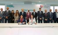 UK's BII, local bank announce $75m finance facility for farmers


