Canadian wildfires degrade air quality in midwest, northeast US
According to Canadian Interagency Forest Fire Center, around 1,586 fires have burned more than 1 million hectares across Canada since the start of the year
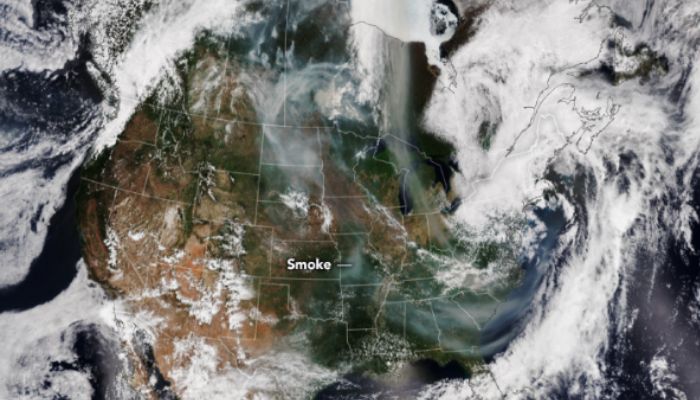
Hazardous smoke from Canada’s wildfire season has triggered the worst air quality in the U.S. with NASA’s EPIC (Earth Polychromatic Imaging Camera) satellite image confirming a haze over North America.
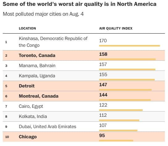
The most affected areas are the parts of the Midwest and Northeast U.S., with Detroit, Chicago, and Minneapolis ranking among the world's most polluted cities as of August 3, 2025.
Just in 2025, around 4,000 fires have burned across Canada with over 700 still active including 500 considered out of control. This marks the second-worst season on record.
Persistent wind gusts are funneling thick smoke southward, worsening the air quality from Wisconsin to Maine.
Minnesota has also been affected severely, experiencing its most-extended air quality alert since 2008, with seven consecutive days of “red” (unhealthy) AQI levels.
Health officials caution that the poor air quality can cause damage to even healthy individuals by causing coughing, eye irritation and allergies.
Vulnerable groups may face high risks of asthma attacks or cardiovascular events.
Currently, the haze is crossing the Atlantic, expected to reach Ireland by August 5, 2025, and Western Europe by midweek.
Meanwhile, Western U.S. states face dual threats, with 16 active fires in California. This includes the 50,000 acre Gifford Fire that forces hundreds of evacuations and smoke drifting from massive blazes in Arizona and Utah.
With 16.3 million acres burned so far, Canada is also at risk of extreme drought. In the given condition, storms may bring relief to some regions but officials warn that the smoky pattern could linger, urging at-risk populations to limit their outdoor exposure.
-
 FIFA World Cup sparks wave of baby Erling Haalands in Peru
 -
 Children’s book predicts FIFA World Cup final?
 -
 Final Fantasy 14 mobile is shutting down for good: Here’s when
 -
 Europe faces fresh climate crisis: Wildfires, drought and storms persist even as heat recedes
 -
 Can Andy Burnham become Britain’s next Prime Minister? Key facts explained
 -
 Trump reignites election debate, renews push for SAVE America Act in primetime speech
 -
 Drake leaves students speechless on first day at Kai Cenat's Streamer University
 -
 Trump's teleprompter operator made more than $100K betting on his speeches: Sources


