Google’s AI model acts as virtual satellite for planet climate
Google introduces a new AI model called Alpha Earth foundation to analyze environmental issues
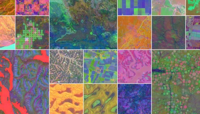
Google has introduced a new AI model called the AlphaEarth foundation, which was developed by Google DeepMind. Its prime motive is to function like a virtual satellite, analyzing climate changes and other environmental issues.
The model integrates large amounts of data from various sources, including optical satellites, radar, and climate stimulations.
AlphaEarth Foundation, a model developed by Google DeepMind, aims to leverage machine learning and the encoding decoding of data, basically a large amount of data that Google has been preserving for the last decades. This will help to better identify significant changes over time.
Understanding the system model and its applications
The first step is data compression, where the model takes terabytes of raw data from sources like satellites, radar, and climate stimulations and creates highly impactful summaries.
Detail Mapping
The second process involves a series of color-coded maps that act as filters. These filters play a key role in revealing detailed information, including material properties, groundwater sources, and human constructions such as farms.
The system ultimately plays a pivotal role in providing detailed information about the Earth's surface, such as tracking climate change and observing urban development.
Meanwhile, Google’s new model has already made its mark in Antarctica, an area which is difficult to capture with regular satellite imaging. It also supposedly outlined certain variations in Canadian agricultural land that are not visible to the naked eye.
In this regard, a research engineer at Google DeepMind highlighted two main problems for making all the information reliable and accessible.
He said in a press briefing, “Before, the challenge was getting a look at it all, Now, the challenge is to unify all the ways that we have to observe and model our planet and get a complete picture.”
However, Google has been facing issues with the accuracy of its AI overviews feature in search, the task of analyzing and compressing petabytes of satellite imagery in a more direct and reliable task for AI.
According to Google, the models are not perfect, and the accuracy for generating enough data for a 10-meters may have occasional errors.
However, the model is reportedly up to 23.9 per cent more accurate than similar AI models.
The founder of MayBiomas, Tasso Azeved said, “It's very difficult to compress all the information available for a piece of land in a traditional way, which is spent literally hours and hours and hours of preparation."
After working with Google to test AlphaEarth for the past 18 months or so, Azeved says, "The software has made it easier to analyze great swathes of rainforest yet keep that data from overwhelming their storage capabilities."
“We were not even scratching everything that would be possible.” he further added.
New capabilities have been added to the Alpha Earth Engine, a cloud-based program that was first launched in 2010. It is hoped that this will enable further mapping by several organizations, such as NASA and Unilever.
Further, Google is proactively addressing concerns about its new system that scours pictures from the sky.
The company is of the view that the AlphaEarth dataset cannot capture the identification of a particular object, person or face.
-
 Rafael Jodar explains what happened to ball girl after viral video sparks backlash
 -
 Backrooms leads Hollywood’s new YouTuber box office boom
 -
 Dog plunges over cliff edge: What happened next?
 -
 ‘KPop Demon Hunters’ director excites fans with hints to new sequel
 -
 PlayStation Plus 12-month membership giveaway officially announced– But there’s catch
 -
 Pete Davidson applauds ex-girlfriend Kim Kardashian's acting skills: 'She's a superhuman'
 -
 Xbox delays Fable to 2027, clears path for GTA 6
 -
 Claude Lemieux cause of death sparks concerns among hockey community


