Print Story
X

Will the government’s move to issue a new political map, showing entire Jammu and Kashmir as part of Pakistan, help change the status quo?
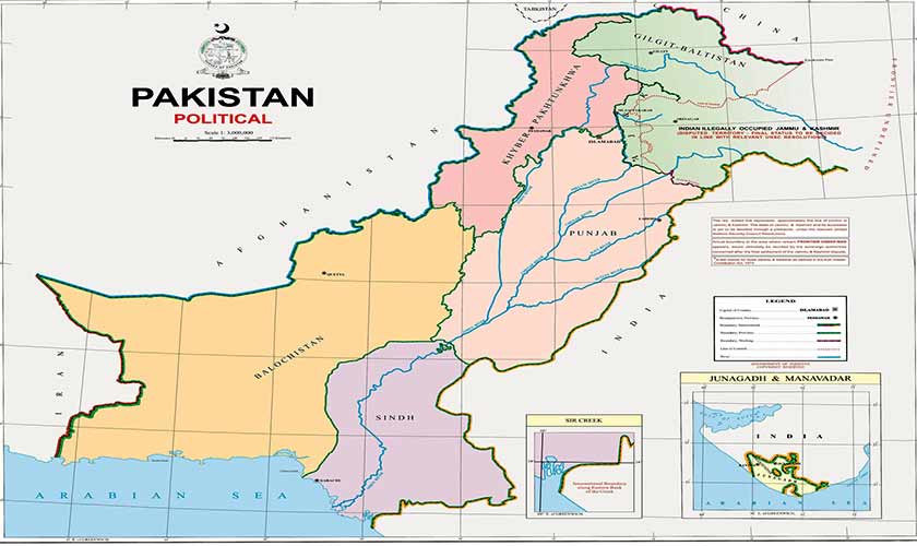
In a dramatic move, the federal government has issued a new political map of Pakistan, touting this as an answer to Indian legislation to change the status of the Occupied Jammu and Kashmir.
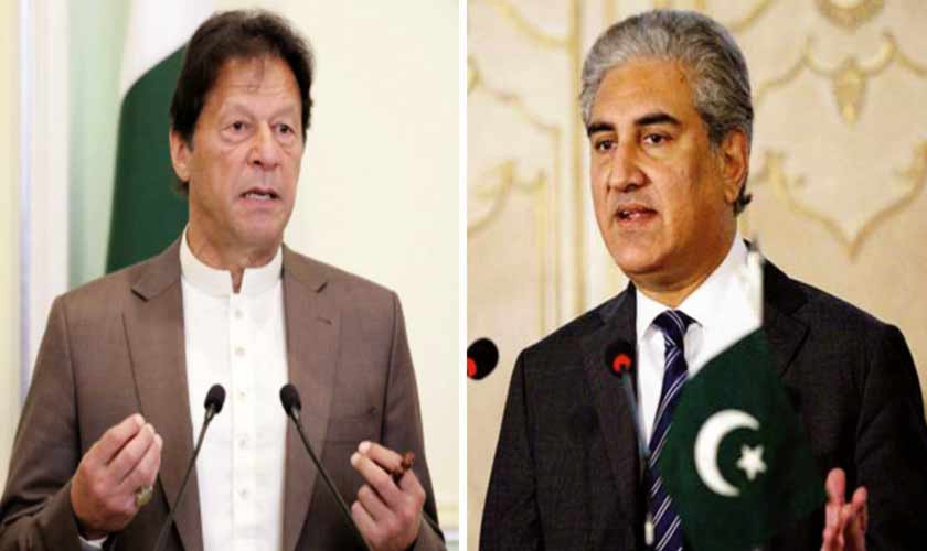
“The map, which we are presenting before the world, endorses the sentiments of the people of Pakistan and the people of Jammu and Kashmir. From now onward this will be the official map of Pakistan,” Prime Minister Imran Khan said while addressing the nation on the launch of the new political map on August 4.
“This is a historic day. The new official map will henceforth be used in schools and colleges across the country. The [only way to a] resolution of the Kashmir dispute lies in [complying with] the UN Security Council resolutions that clearly give the Kashmiri people the right to self-determination,” the PM said.
“Pakistan will continue its political struggle for the people of Kashmir. We believe that the Kashmir dispute can only be resolved through political means. We don’t believe in military solutions.”
“Pakistan has always considered Kashmir as its part. This is a first step in that direction. We will continue to remind the UN of its promise to the people of Kashmir that is yet to be fulfilled. The map is backed by all political parties of the country. This map rejects the Indian government’s illegal action on August 5 last year.”
The prime minister said the only solution to the Kashmir issue was through the UN Resolution 39, adopted on January 20, 1948. “It gave the right to Kashmiris to merge with either Pakistan or India. The Modi government is trying to move people from India to Kashmir to turn its people into a minority in their own region.”
In August 2019, India had changed the constitutional status of Jammu and Kashmir, making it a Union territory in violation of the international resolutions and bilateral agreements with Pakistan. India had then released a map showing Azad Jammu and Kashmir and Gilgit-Baltistan as parts of the new Union territory.
The release of the new political map is considered symbolic. It changes the status of Jammu and Kashmir according to Pakistan, from disputed territory to Pakistani territory.
“Pakistan believes that the solution of this dispute with India lies only in implementation of United Nations Security Council resolutions and ensuring an independently conducted plebiscite giving Kashmiris their right of self-determination,” Foreign Minister Shah Mahmood Qureshi said while unveiling the map. “The administrative maps have been introduced before, but this is the first time that a map reflecting the aspirations of the people has been released. The map clearly shows Occupied Kashmir as a disputed territory. The only solution to the issue would be through the UNSC resolutions and as per the aspirations of the Kashmiri people,” he said.
“It has been made clear that Siachen is a part of Pakistan. We are challenging their illegal occupation and claiming our right to the area. Pakistan has also rejected India’s claims about Sir Creek. We have pointed out that the border is on the eastern bank although India had claimed that it is towards the west. By making this false claim, India has been trying to deprive Pakistan of several acres of the country’s exclusive economic zone,” he said.
“Further, the erstwhile FATA is now shown as part of Khyber Pakhtunkhwa province. The entire nation is united on the country’s new political map. The federal cabinet, the Kashmiri leadership and Pakistan’s political leadership have endorsed the government’s decision,” he said.
“This gives a clear message to the people of Kashmir that the government of Pakistan will continue to support them. Our destination is Srinagar. This is a historic day,” Qureshi had said.
The map shows Jammu and Kashmir, including Gilgit-Baltistan, in a distinct colour. The Line of Control (LoC) has been marked as a red dotted line. The map carries the sentences: “The red dotted line represents approximately the LoC in Jammu and Kashmir. The matter of its accession is yet to be decided through a plebiscite under the relevant UNSC resolutions.”
“The updated map showing ground realities while preserving our legal position on Kashmir dispute, embedded in UNSC resolutions, is a welcome step forward. Showing the disputed territory in our map reinforces its disputed status. It is an emphatic political statement by Pakistan,” says Aizaz Chaudhry, a former foreign secretary.
The map has an area titled “frontier undefined” and the words, “Actual boundary in the area [...] would ultimately be decided by the sovereign authorities concerned after the settlement of the Jammu and Kashmir dispute.” Another important change in the map is revival of Pakistan’s claim on Junagadh and Manavadar.
Reacting to the new map, India has called it “an exercise in political absurdity”. “These ridiculous assertions have neither legal validity nor international credibility. In fact, this new effort only confirms the reality of Pakistan’s obsession with territorial aggrandisement supported by cross-border terrorism,” India’s Ministry of External Affairs said in an official statement. The Pakistani Foreign Office, however, rejected the Indian reaction. “We categorically reject the statement made by the Indian Ministry of External Affairs (MEA) on Pakistan’s political map. Through sophistry and obfuscation, India cannot create a smokescreen for its illegal and unacceptable actions in Indian-occupied Jammu and Kashmir, including those taken since August 5, 2019,” Foreign Office Spokesperson Aisha Farooqui said in a statement late on August 4.
“The updated map showing ground realities while preserving our legal position on Kashmir dispute, embedded in UNSC resolutions, is a welcome step forward. Showing the disputed territory in our map reinforces its disputed status. It is an emphatic political statement by Pakistan,” former foreign secretary Aizaz Chaudhry told The News on Sunday.
“Kashmiris in the Occupied Kashmir are waging a heroic struggle. India’s repression is unprecedented. The people and government of Pakistan stand with the people of Kashmir. The world is beginning to realise the gravity of the situation. Pakistan must use every channel to show the world the true face of Hindutva-driven Modi government which is suppressing the minorities in India especially Muslims,” Chaudhry says.
The world must know that in Occupied Kashmir, the Indian government is committing the worst kind of human rights violations and setting the stage for a genocide, he said.
“Already through a domicile law the Indian government is trying to bring about a demographic change in the Occupied Kashmir thus violating international law embodied in scores of UNSC resolutions.”
“The new political map cannot be dismissed as a gimmick for domestic consumption,” Najmuddin A Shaikh, former foreign secretary and expert on foreign affairs, says.
“A careful study of the map shows that it is largely the map that the Survey of Pakistan has been printing as part of (authoritative) political maps of Pakistan in terms of the state of Jammu and Kashmir”, he says.
“Those maps showed entire Azad Kashmir as part of Pakistan with appropriate notes for Indian Occupied Kashmir. This [new map] certainly does not negate our case on Kashmir which rests on the UNSC resolutions and the Simla Agreement which calls for the two countries to negotiate a final solution. The last UN resolution said in layman language that no changes in the disputed nature of the territory could be made by elections or any other measure by occupation forces,” Shaikh says.
Interestingly, the new map has been adopted by the federal cabinet and not by the parliament.
Talking to the media, Adviser to Prime Minister on Parliamentary Affairs Babar Awan claimed that all the political parties had the same stance on the Kashmir dispute. “The new map, which was unanimously approved by federal cabinet, has also been issued. It will also receive approval from the parliament,” he said.
On August 4, the government held a briefing at the Foreign Ministry. Chaired by Foreign Minister Shah Mehmood Qureshi, the event was attended by National Assembly Speaker Asad Qaiser, Federal Minister for Information and Broadcasting Senator Shibli Faraz, Minister of State for Parliamentary Affairs Ali Muhammad Khan, Minister for Kashmir Affairs and Gilgit-Baltistan Ali Amin Gandapur, Parliamentary Secretary for Railways Mian Farrukh Habib, Prime Minister’s Special Assistant on National Security Moeed Yusuf, and the Inter-Services Intelligence Director General Lt Gen Faiz Hameed.
Senator Sherry Rehman, Syed Naveed Qamar and former prime minister Raja Pervez Ashraf represented the Pakistan Peoples Party. The Pakistan Muslim League-Nawaz was represented by Khwaja Asif, Mushahid Hussain Syed and Raja Zafarul Haq.
The government called it an all parties conference, meant to take opposition parties into confidence on steps it was taking on Kashmir. However, opposition members seemed unhappy at the PM’s absence from the event. They also said it was a briefing and not a conference.
Later, talking to the media, Senator Mustafa Nawaz Khokhar of the PPP, who attended the meeting, said the government had “only informed them” about the new political map. “So far, we have not endorsed the move. The party will take a clear stance on the issue after a discussion in the core committee meeting,” he said. Senator Mushahid Hussain Syed, however, said the PML-N had endorsed the new map as there was nothing objectionable about it.
The writer is a staff member. He can be reached at vaqargillani@gmail.com