Print Story
X

The recent flood phenomenon merits a deeper dissection rather than a superficial mourning and condemnation
The media remained preoccupied with frantic news coverage and discussion programmes on floods during recent weeks. The government took flak for its inability to take appropriate measures to mitigate the impact of the 2015 flood.
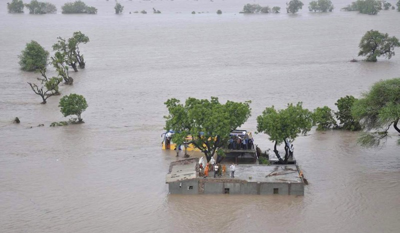
Peak flow in the Indus was around 700,000 cusecs yet more than 3,500 villages were affected in Sindh and Punjab afflicting a population of more than 1.3 million. Considering the design discharges of various barrages, the quantum of flow was much less than the critical threshold, yet large areas were inundated.
While customary criticism of the government is not completely unfounded, the causative factors did not come under discussion. The phenomenon merits a deeper dissection rather than a superficial mourning and condemnation.
With all due empathy for the affectees, the flow was technically not a flood and it should not have caused devastation of such proportions. The flood was confined within the river embankments and no breach or over topping of bunds occurred. In other words, a normal flow has now become a source of disaster. The simple reason is massive encroachment of flood plain popularly called katcho area.
Demanding new dams to control floods while glossing over the culpable factors is completely uncalled for. Treating knee for an injured arm would proffer no relief. In the past years, people in Katcho area would rejoice such floods but now poignant stories are televised depicting massive displacement, hectic evacuation, damaged houses and long queues of relief camps with photo sessions by the ruling elite. Denuded watershed of Indus, encroached natural waterways, sprawling human settlements in flood plains, massive deforestation, burgeoning agriculture amid katcho area and construction of a series of vehicular bridges that contracts throat of the river are key factors that have drastically altered the river regime and converted normal flows into ravaging floods.
Between Kashmore and Indus, the katcho area of Sindh is spread over more than two million acres. It is roughly divided into the present and the abandoned river channels (600,000 acres), forest lands (450,000 acres), roads, settlements and government structures (50,000 acres) and agriculture land (one million acres).
Reliable estimates of the population in Katcho are not available, however a conservative count puts it close to one million. A report of Pakistan Institute of Labor and Research (PILER) mentions Katcho population in Sindh as 3.5 million. This explains a sizeable number of villages and people getting affected almost every year.
Long ignored land use planning and faulty development plans forced the marginalised rural communities to settle along the river course. Dwellers of katcho were noticeably resistant to evacuation during floods as their asset-base was tied to the flood plains.
Traditionally people in Katcho area would abandon their abodes during monsoon season and return after recession of flood. Leaving tons of nutrient rich silt and recharged aquifer, the floods used to be a boon for katcho community. People would just strew seed to have bumper harvests in the post-flood season. katcho area had been a breadbasket of Sindh and South Punjab. Seasonal inundation of katcho would be heralded as a sign of rich seasonal harvest. Profusion of organic grain, pulses, dairy and forest products would guarantee prosperous livelihood for the katcho community.
However, rampant damming and diversions of Indus during the recent decades have changed the flood regime entirely. Before Tarbela dam, the katcho area of Sindh received a flood of 300,000 cusecs, almost every year and a flood of 500,000 cusecs for three out of four years i.e. for 77 per cent of years.
Tarbela dam and other barrages completely altered the flood pattern. Vast tracts of the land, previously part of the flood plain, were exposed as parched land that enticed people to create new settlements. Local influential people in connivance of sordid bureaucracy replaced natural forests with agriculture fields fenced by illegal bunds.
The network of illegally erected dykes inside the floodplains is not a result of mere administrative negligence, it is rather a criminal act patronised by influential people in power corridors. Successive governments brazenly leased out forest land by tweaking rules and regulations with complete impunity. Unscrupulous elements seized this heaven sent opportunity and katcho area gradually morphed into pacco (regular) area.
According a report some 1.8 million acres of katcho land is occupied by various influential elements. Makeshift hamlets were supplanted by properly constructed villages networked through metalled roads and equipped with modern facilities like electricity, schools etc. With a massive influx of population, the whole landscape of katcho went through an irrevocable sea change.
According to a PILER’s report, a satellite imagery of 2010 validated this shift. The satellite data showed that since 1980 forest in katcho area of Sindh has shrunk from 9.52 per cent to only 0.72 per cent whereas agriculture land has sprawled from 23.41 to 58.23 per cent. Vast parcels of the occupied katcho land locally called Keti are controlled by local feudal elements. Keti Khuhro, Keti Mumtaz, Keti Jatoi, Keti Bughya and Keti Kharal are few such examples.
These Ketis are virtually personal fiefdoms of local feudal lords where no law has any access. They conscript the marginalised local communities to plough their land and minister their local interests. However, when floods displace these landless farmers, feudal lords abandon them at the mercy of official aid and philanthropic charity. They generate fortunes through virtually enslaved farmers and evade taxes as well, yet abdicate their subjects when their rickety huts are inundated. Misdirected forestry policies also wiped out natural forests and augmented illegal agriculture in the floodplains. During one unit period, forest land of Sindh was mercilessly colonised in the garb of agriculture development.
Another deleterious development is reckless construction of new vehicular bridges on Indus to mesh cities on both sides of the river. While bridges fulfill vital communication needs, their location and design have serious implications for river flows. Sites for these bridges are not selected on technical grounds but to bribe influential political leaders.
For example, alignment of the bridge connecting Larkano and Khairpur district was changed several times to appease local political and feudal oligarchy. Span of these bridges is much less than the width of riverbed. For example the length of Larkano-Khairpur bridge is 1.22 kilometres whereas the riverbed between the two embankments is 13 kilometres wide at the location. Similarly, the Kazi Ahmed-Amri bridge is 1.32 kilometres long against 9 kilometres wide belly of Indus at the same location.
This contracted trachea of Indus impedes the flow and creates local pond that shoves bunds and make them vulnerable. National Highways Authority, Irrigation Department and provincial government are directly responsible for this mess. The enigmatic dimension of the 2010 flood was the abnormally long travel durations of peak flows between barrages in Sindh. The flow that normally required 24 hours from Guddu to Sukkur barrage took 33 hours. Likewise the time-lag between Sukkur and Kotri was an astounding 408 hours as against the normal time-lag of 72 hours. This was partially because of the sustained inflows from upstream yet the impact of narrowed sections at bridges may also have been a contributing factor.
Therefore, the role of newly-built bridges needed to be examined. These bridges are built without beforehand Environmental Impact Assessment (EIA) and proper study of their impact on flood flows.
Supreme Court of Pakistan constituted a commission to probe into the factors that caused 2010 floods and recommend remedies. The commission amply underlined the aforementioned aspects.
The commission report reads "unfortunately, the local and provincial governments have themselves indulged in encouraging illegal acts promoting encroachments. Unauthorised and technically unsound public works have been executed by local authorities. Construction of roads and gas pipelines has been allowed to pass through bunds in contravention of legal provisions. All such encroachments have contributed to obstructions in the flow of water resulting in flooding of many areas. A matter of grave concern which came to the notice of the Commission was that some of the governments are selling acquired lands in pond areas to raise revenues. Under the law, no construction of any infrastructure is allowed to be erected within a distance of 200 feet from banks of the rivers/streams. The governments must correct that and ensure that no encroachments are permitted and no acquired lands are sold or leased out. Actions should be initiated by governments to remove all encroachments with a firm hand."
The experience of recent floods provide ample evidences that floods can be managed through non-structural measures such as properly maintaining watershed areas, stamping out all kinds of encroachments from the floodplain and natural waterways, purging unscrupulous elements from the irrigation and revenue departments, developing and executing a comprehensive land use plan, rejuvenating riverine forests and imposing strict regulation of river regime. These measures can considerably mitigate the impact of flood and should precede the demand for controversial and politically incendiary structures like dams.