World's largest underwater volcano eruption happened 7,300 years ago
World's largest underwater volcano Kikai-Akahoya eruption is said to have taken place in Kyushu Island, Japan
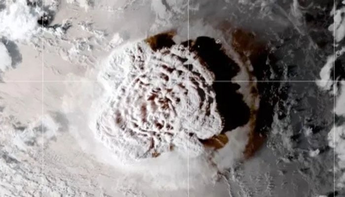
The greatest known volcanic eruption, which occurred 7,300 years ago and released more than twice as much rock and ash as the previous record-holding eruption of Indonesia's Mount Tambora in 1815, has been identified by scientists.
The Kikai-Akahoya eruption, which caused immense destruction, transpired to the south of Kyushu Island in Japan, where the Philippine tectonic plate subducts beneath the Eurasian plate.
A report published online in the Journal of Volcanology and Geothermal Research on February 1st states that, in the previous 140,000 years, the undersea Kikai volcano is known to have generated three large eruptions, the most recent of which was the Kikai-Akahoya eruption.
Although the old volcanic blast was already well known to experts, the new research has identified its record scale and identified it as the greatest eruption of the modern geological age.
"The eruption has been known for a long time, but these authors are increasing our knowledge of it a lot," Tim Druitt, a professor of volcanology at the University of Clermont Auvergne in France who reviewed the study, told Live Science in an email.
Because of the inherent difficulty of accessing the underwater volcano, scientists had previously found it difficult to determine the extent of the eruption and what caused it.
In the latest study, a precise map of the seabed surrounding the volcano was created by experts using seismic data. The scientists used a remote-controlled robot to drill into the seabed at several spots and retrieve sediment cores in order to sample the massive underwater deposits that were shown on the map.
-
 UK targets 87% emissions reduction by 2040
 -
 ‘El Nino is arriving on our doorsteps with 90% certainty’: UN chief Guterres warns with climate urgency
 -
 Trump suggests canceling Great American State Fair performances after several musicians withdraw
 -
 Nancy Guthrie investigation update: FBI’s next step could identify key suspect, expert says
 -
 UN warns strong El Nino could drive global temperatures higher: Here’s what to know
 -
 Why the Meta whistleblower’s lawyer says he is also barred from promoting her book
 -
 Hegseth blocks promotions of several Navy officers to 1-star rank: Here’s why
 -
 US holds significant talks on expanding nuclear weapons deployments across Europe
-
 Tom Kean runs unopposed in key New Jersey battleground despite questions over Washington absences
 -
Hezbollah agrees to US-backed ceasefire proposal as Israel warns strikes could resume
-
Netanyahu faces political pressure as Israel parliament backs early election bill
-
Florida sues OpenAI, claims ChatGPT aided mass shooters and endangered children


