Tropical Storm Ophelia approaches East Coast, prompts warnings in North Carolina and Virginia
As North Carolina and parts of the mid-Atlantic gear up for a damp and blustery weekend, storm Ophelia's landfall looms on the horizon
Tropical Storm Ophelia is making its presence felt off the East Coast, with the latest data from Hurricane Hunters indicating increased strength.
As North Carolina and parts of the mid-Atlantic gear up for a damp and blustery weekend, the storm's landfall looms on the horizon.
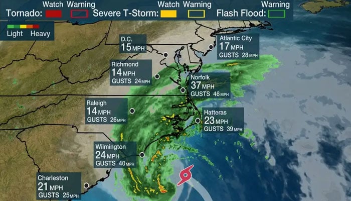
With maximum sustained winds reaching 70 mph and higher gusts, Ophelia is poised to affect areas well beyond its centre, unleashing several inches of rainfall as it tracks up the coastline. The National Hurricane Center has issued a hurricane watch for portions of eastern North Carolina as the storm advances north-northwestward at a speed of around 13 mph.
Ophelia's centre is expected to draw close to North Carolina's coast on Friday night, according to the National Hurricane Center.
While additional strengthening isn't the most likely scenario, the potential is being acknowledged as Ophelia approaches the warm waters of the Gulf Stream en route to eastern North Carolina. Hence, a Hurricane Watch has been issued for a section of the North Carolina coast.
The brunt of the heaviest rain and wind will be felt along coastal areas, but inland residents won't escape the impact either. Ophelia's target is a Saturday landfall in North Carolina, but by the time it's done, its influence will extend northward, reaching as far as southern New England.
Coastal power outages are a concern, especially along the coast. In response, North Carolina Governor Roy Cooper has declared a state of emergency for the entire state, facilitating emergency responses to mitigate the storm's effects.
The heavy rainfall and gusty winds are set to worsen throughout Friday evening and into the night as the storm edges closer to the coast, prompting tropical storm warnings spanning from just south of Charleston, South Carolina, to the Maryland-Delaware state line. Storm surge watches and warnings extend from Surf City, North Carolina, to the Chesapeake Bay.
In addition to the rain and wind, some areas along the coastal mid-Atlantic face a potential tornado threat. Eastern North Carolina and southeast Virginia are particularly at risk, with forecasts indicating 3 to 5 inches of rain, and localised areas could see up to 7 inches due to strong thunderstorm bands.
A wide swath of the mid-Atlantic to southern New England is bracing for 2 to 4 inches of rainfall from late Friday through the weekend.
Coastal regions should also be prepared for storm surge, coastal flooding, rip currents, and rough surf. In certain areas, surges of 1 to 5 feet are conceivable, especially in inlets and rivers from Surf City, North Carolina, to Manasquan Inlet on the New Jersey shore.
The highest risk of storm surge flooding coincides with Saturday's high tides, primarily in the coastal region stretching from New Jersey to the Virginia Tidewater.
A considerable number of flood gauges in the area are predicted to reach moderate or major flood levels on Saturday, heightening concerns of coastal flooding and impassable roads for those closest to the coast.
-
Trump vows ‘no going back’ on Greenland ahead of Davos visit
-
Japan’s ex-PM Shinzo Abe’s killer is set to be sentenced: How much punishment could he face?
-
Therapist killed in office as former client launches knife attack
-
North Carolina woman accused of serving victims with poisoned drinks
-
'Greenland will stay Greenland', former Trump adviser hints at new twist
-
Stranger knocks, then opens fire on Indiana judge and wife
-
Japan unveils anti-ship missile with ‘barrel-roll’ evasion to outsmart defenses
-
Missouri couple ‘locked sons in chicken pen, shot them’ in shocking abuse case


