Print Story
X

The Eastern Bypass is supposed to provide an easy and convenient passage to the northern part of Lahore, from the GT Road. But it should also include in its planning ambit the restoration and accessibility of the city’s historical monuments
The mention of Shahi Bagh Project, when the foundation stone was laid recently for the Eastern Bypass, has raised hopes that the acclaimed heritage sites of Lahore are being taken seriously with an effort at restoring their preeminent place in the city.
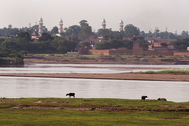
The British made Lahore to turn its back on the River Ravi. With Ranjit Singh building a cantonment for his European generals around the tomb of Anarkali -- now home to the civil secretariat of the Punjab government -- and, later, the British laying their cantonment in Mian Mir across the city, the face was turned away from the river without any proper planning for the once-posh localities. Since then, only the slums have been allowed to mushroom as the focus shifted to developing the Mall, the Lahore Cantonment and all those areas adjacent to it. It is about time the wrong done to the river and the city was set right, as conceived by its original authors.
The earlier builders including the Mughals had built the city on both sides of the Ravi, with the stream of water running right through. It may have served other purposes also but it certainly made the city look beautiful in full cognisance of the importance of the river in terms of its sheer aesthetic presence.
The Lahore Fort lay on the river and so did the Badshahi Mosque. Even Ranjit Singh’s Samadhi was built here, as it was considered a prime spot of the city. Further up, there were the localities of Mughalpura where the Mughal royalty lived along the river in big sprawling gardens from where Lahore got its reputation of being the ‘City of Gardens.’
The culmination of it all was the Shalimar Gardens which opened out into the river. That is where the entrance of the Gardens was and, on the highest echelon of the tier, the emperor sat symbolically surveying his domain from that vantage point.
Unfortunately, when the British built the Grand Trunk (GT) Road they aligned it along the Shalimar Gardens’ highest tier. The actual entrance from the first tier was blocked, fell into disuse, then decay, and the upper two or three tiers were thought good enough to be saved and maintained.
The order was reversed as ironically one entered the upper tier of the Gardens for the last hundred-and-fifty odd years, and then went down a couple of tiers before the unkempt part of the place begins.
From the side of the river the big gates have been closed, actually barred, it appears permanently, and one can see houses taller than the garden walls looking over Shah Jehan’s replica of paradise. Some of the houses have even used the existing boundary wall of the Shalimar Gardens as part of their structures.
Across the river, there is the tomb (or mausoleum) of Jehangir that too opened out on to the river. This was the garden that was laid out by Nur Jehan, and this was where she spent her last years as a prisoner. Her tomb, much modest in comparison, is also lying at some distance as is that of her brother Asif Jah aka Asif Khan.
Sadly, when the railways was established, it cut through this beautiful garden and destroyed its serenity forever. This area, like that of Shalimar Gardens, is also very congested and there are many encroachments that make the passage to the monument difficult. It is also very unsightly.
People today seem to have forgotten that there existed a majestic structure in Shahdara, which was populated by visitors and picnickers some twenty years ago, especially during monsoons and winters.
The Eastern Bypass is expected to change the destiny of the locality along the river and open the possibilities of bringing back these monuments to their past glory. But the access to these places and sites must be improved and the encroachments removed, the river front cleared, and the access or at least the view from the river made functional and rehabilitated to what it must have been as first conceived and built.
The Ring Road that begins in Shahdara, along the Mehmood Booti Bund, provided another route -- a bigger one -- to the localities to the north of Lahore. These localities were inaccessible with all kinds of problems such as drainage and very narrow roads. But the interchanges from the Ring Road have changed the destiny of the area which has started to develop just because it is more accessible now and is considered not a kachi abadi or a slum but as one that is integrated with the rest of the population.
The new road -- the Eastern Bypass -- should not only provide an easy and convenient passage to the northern part of Lahore, from the GT Road and then on to the Eastern Part and Southern Part to sectors in Defence and also the airport right up to the Motorway Interchange, it should also include in its planning ambit the restoration and accessibility of the abovementioned historical monuments, followed by the restoration of their original access.
The two banks of the river should again be converted into parks and gardens (public and not private, as these were in Mughal era), and the river be replenished.
Earlier, there was a plan to make a lake on the river bed. After some initial enthusiasm, it was put on the backburner. With the situation of the underground water table in and around the city of Lahore, the sooner the river lake project begins the better. It will not only improve the look of the city, which is important, but also replenish the underground water table, the depletion of which is assuming critical importance.