Print Story
X

A vigilant watch over weather is needed to ensure a timely response in case of any development across the border
| I |
n the waning days of the monsoon season, the Punjab has received a devastating cross-border deluge. Since the flood originated due to abnormally heavy rains in the bordering states of India, averting the surge in the Sutlej and Ravi rivers was practically impossible.
The Indian states of Punjab, Haryana and Himachal Pradesh received malevolent monsoon spells during July and August. Heavy rain spells resulted in severe flooding and landslides in Himachal Pradesh, the Punjab, Haryana, Uttarakhand, Jammu and Kashmir, Rajasthan and Delhi. These inflicted an enormous loss of life and property. Two hundred twenty-seven people lost their lives in Himachal Pradesh. Chief Minister Sukhwinder Singh Sukhu claimed that the state had suffered losses of over 10,000 crore rupees. In July alone, 105 people lost their lives across Himachal Pradesh, Uttar Pradesh and Delhi due to intense rain and flooding. Delhi received over 153 millimetres of rain on July 9, breaking a 40-year record of single-day precipitation. It dislodged more than 16,000 people settled near the swollen Yamuna River.
August brought another catastrophic wet spell that resulted in 80 deaths in Himachal Pradesh and Uttarakhand. Torrential rains also hit Simla, triggering landslides, destroying infrastructure and killing 57 people. Himachal Pradesh was the worst hit again with 330 dead, 38 missing and over 100 injured. More than 9,000 houses have been damaged since April. Thousands of people have been evacuated to relief camps. Schools, flights and train operations have been hindered.
Intense rainfall during August 10-14 raised water to an alarming level in the two major dams, Bhakra (Sutlej river) and Pong (Beas River). Bilaspur received 92 percent, and Hamirpur 127 percent more rainfall than normal. Himachal Pradesh received 166 percent higher rainfall on August 10 and 70 percent on August 12. The abnormal downpour brought a huge amount of inflow to the dams. A baffled Bhakra Beas Management Board (BBMB) decided to discharge excess water through the floodgates to avoid risk to the structures. Bhakra and Pong dams were discharging 80,000 and 100,000 cusecs, respectively. The resulting flood inundated hundreds of villages in the Kangra district of Himachal Pradesh and Ropar, Anandpur Sahib and Hoshiarpur districts of the Punjab located along the furious Sutlej and Beas rivers. Authorities jostled to safely relocate more than 100,000 people after the flood submerged the dry bed of Sutlej. Hundreds of settlements and thousands of acres of cropland in the Indian Punjab were inundated.
Indian media and civil society have criticised the abrupt release of flood from Bhakra and Pong dams, two of the biggest constructed in the Punjab, Haryana and Rajasthan. The BBMB has been accused of reckless management of the two reservoirs that completely disregarded the impact on the downstream areas. On August 14, when heavy rain lashed the catchment of the two dams, both were overflowing. As per operational guidelines, these dams should have discharged enough water earlier to absorb the monsoon inflows during August. Between August 11 and 15, the water level in Bhakra Dam rose from 1,374.20 feet to 1,399.65 feet, an abrupt rise of over 25 feet in four days, leaving the dam at full capacity. During early August, when there was no rain, the authorities had released around 18,000 cusecs of water against an inflow of more than 500,000 cusecs. The ‘irrational’ storage of water in August is now being questioned by some experts. The lack of transparency of data on inflow and outflow in the dams is also being debated.
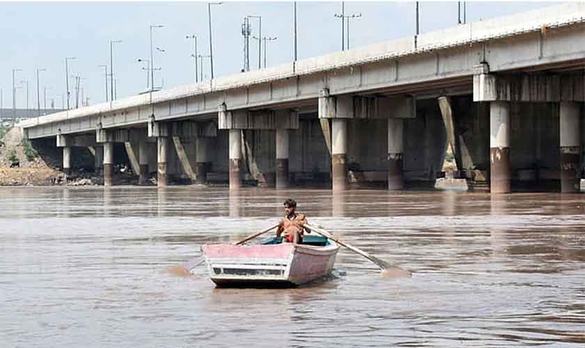
The imminence of a flood caused alarm bells to ring in Pakistan. The administration, as well as the people, were alerted along the river course. The flood wreaked havoc in Kasur, Okara, Pakpattan, Lodhran, Bahawalnagar, Vehari and Bahawalpur. Sutlej enters Pakistan at the Kasur-Ganda Singh Border, and after re-entering India flows into Pakistan near Ferozpur’s Hussainiwala border. The dried-up river now received a massive flow of 278,000 cusecs, the largest flood in 35 years. The spate of flood occurred after mid-August, displaced over 300,000 people from 548 villages, and submerged over 150,000 acres of cropland. It created a trail of destruction with its downstream movement in several districts of the Punjab.
Last week, the Raj-era Empress Bridge near Bahawalpur passed 130,000 cusecs. The flood triggered panic around Bahawalpur as a number of zamindara (private) protective dykes collapsed. Three villages, Weaslan, Sahlan and Lal De Goth, on the outskirts of town were inundated. The administration swung into action and evacuated over 128,000 people and 50,000 cattle before water flushed their settlements. The operation was carried out by 1,000 rescuers using 250 boats. In addition to the three washed up mozas, another 55 were affected. Standing crops over 47,000 acres were swept away. While the losses were enormous, the flooded areas are likely to benefit from a bumper Rabi crop on account of the fresh recharge and silt layer. Large swaths of hitherto uncultivated areas are also expected to be ploughed. Nonetheless, poor communities have lost their abodes and ought to be compensated.
The Met Office has predicted another wet spell in the upper catchment of rivers in the first week of September. Contingent upon the amount of water to be discharged by India, it can bring another spate of flow in Sutlej. A vigilant watch over weather is needed to ensure a timely response in case of any untoward development on the other side of the border.
Climate change is likely to cause unanticipated weather patterns in the catchment of rivers that remain dormant for decades. Pakistan should remain vigilant on trans-boundary flows that make floods a fait accompli for the lower riparian. With the limited early warning margin available to the lower riparian due to their close proximity, Pakistan and India should enhance collaboration for improved weather forecasting and frequent consultation on the management of dams and rivers in the neighbouring states during the monsoon season.
Following the dry decades, riverbeds in downstream areas have been heavily encroached upon with human settlements and agriculture fields. Recent watermarks should be used as a benchmark to determine the vulnerability of these areas in the coming years. However, this is easier said than done as it will involve relocating a large population that was irresponsibly allowed to sprawl in the floodplain. Constructing protective dykes along the existing settlements should be considered as a mitigation measure.
It is high time to impose strict prohibitions on further settlement along river courses to avoid mass destruction by floods. A mechanism should be devised to move vulnerable communities towards safer locations and camps at the first sign of a flood. Special relief areas need to be demarcated with a robust rescue and relief plan in the vulnerable areas. A community-based early warning and communication system should be developed to reduce losses during monsoon flows. As far as possible, flood plains should be kept clear through administrative writ. The Provincial Disaster Management Authority of the Punjab should incorporate this experience for annual monsoon contingency plans in the future.
The author is a civil society professional, nmemon2004@yahoo.com