Pakistan unveils new political map including Indian-occupied Kashmir
The final status of "Indian Illegally Occupied Jammu and Kashmir" was to be decided in line with the relevant UNSC resolutions, read the map
ISLAMABAD: The federal cabinet on Tuesday unveiled a new political map of the country, which includes Indian-occupied Kashmir in its entirety.
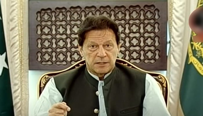
The approval was given in a meeting chaired by Prime Minister Imran Khan earlier today during which participants were apprised of the latest situation in the occupied Muslim-majority region.
Speaking during a live televised address to the nation, the premier shared the details of the decisions made in the Cabinet meeting. "Today is the most important day in the history that we are presenting a new political map of Pakistan before the world," he said.
"The cabinet has approved the map," he said, adding that the Kashmiri and national leadership has also green-signalled it. The new map would now be used in school and colleges as well, he added.
The final status of "Indian Illegally Occupied Jammu and Kashmir" was to be decided in line with the relevant UNSC resolutions, read the map.
'Reject India's tactics'
Foreign Minister Shah Mahmood Qureshi explained the changes made in the new map, saying it reflected the will and aspirations of the people of Pakistan.
Qureshi congratulated the incumbent government for unveiling a map of the country, which included Gilgit-Baltistan as well as Azad Jammu and Kashmir.
"Pakistan has made it clear today that we reject India's tactics and that Islamabad is ready for a peaceful solution to the disputed territories — Gilgit-Baltistan and Kashmir," he said.
"The first thing that this map clears is that the solution to Kashmir will stem from the United Nations Security Council's Resolution [of 1948], which has been printed on the map.
"The second point it clears is that the Siachin is ours and it shall remain that way," he added.
Pakistan's 'destination is Srinagar'
Speaking of Sir Creek, the foreign minister said: "Pakistan denies the Indian claims that it goes towards the West; we have denied that claim and made it clear that our border is on the East."
Qureshi said India had made these claims in a bid to capture several acres of land that were Pakistan's exclusive economic zone. The erstwhile FATA has been merged with the Khyber Pakhtunkhwa province in the map, he added.
The minister said the Cabinet, the Kashmiri leadership, and the Pakistani government had backed this step, noting that it "assures Kashmiris that Pakistan is behind them".
"Our destination is Srinagar [...] today is a historic day," Qureshi added.
Map 'the first step'
Taking over the briefing after the minister, PM Imran said the only solution to the Kashmir issue was through the UN Resolution 39, adopted back on January 20, 1948 and which gave the right to Kashmiris to either merge with Pakistan or India.
"India is trying to shift people to Kashmir in a bid to make Kashmiris a minority in the region," he said.
PM Imran reiterated that his government would raise the plight of Kashmiris on every forum possible. "This map is the first step and our struggle for Kashmir will move forward," he added.
-
 Punjab by-polls: Notices served on minister, SAPM for ‘violating’ election code of conduct
 -
 27th Amendment empowers FCC to hear all constitutional cases: minister
 -
 JF-17 attracts strong attention at Dubai Airshow as friendly country inks procurement MoU
 -
 US lawmakers laud Punjab govt's initiative to modernise brick-kiln
 -
 Security forces gun down 30 terrorists in multiple IBOs in KP: ISPR
 -
 MQM-P calls for new province in Sindh
 -
 US report validates Pakistan military edge over India: PM
 -
 Banned TTP poses serious threat to Pakistan security: UNSC panel


