Water level in Mangla reservoir rose to the level of 1186.40 feet
The official sources told APP here that the inflows of Jhelum river at Mangla dam was recorded 56200 cusecs with the Outflows of 10000 cusecs of water from the reservoir located in Mirpur district of Azad Jammu & Kashmir.
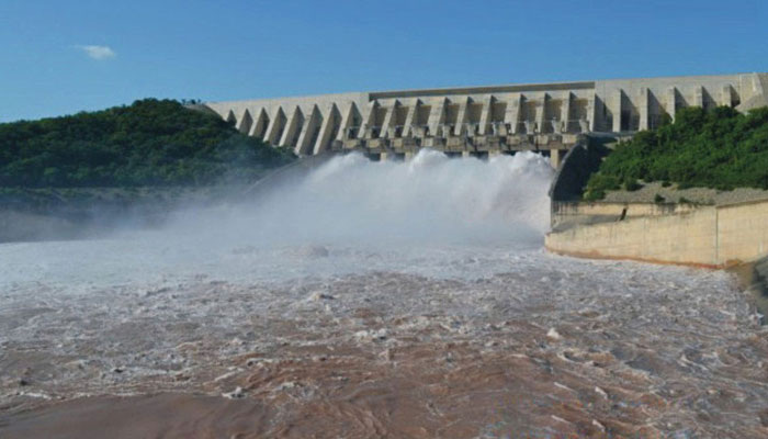
MIRPUR (AJK): As a result of melting of snow at the snow-clad upper reaches of Himalayan belt besides the ongoing torrential rains and subsequent raise in the water in the lakes and rivers falling in the country’s second largest Mangla dam, the water level in the Mangla reservoir Monday rose to the level of 1186.40 feet against maximum conservation level of 1242 feet, live storage capacity of 3.528 MAF.
The official sources told APP here that the inflows of Jhelum river at Mangla dam was recorded 56200 cusecs with the Outflows of 10000 cusecs of water from the reservoir located in Mirpur district of Azad Jammu & Kashmir.
At the same time, the overall position of the river inflows and outflows at Tarbela, Mangla and Chashma along with the reservoirs levels and the barrages remained on Monday as under:
Rivers:
Indus at Tarbela: Inflows 309400 cusecs and Outflows 229500 cusecs, Kabul at Nowshera: Inflows 98400 cusecs and Outflows 98400 cusecs, Jhelum at Mangla: Inflows 56200 cusecs and Outflows 10000 cusecs, Chenab at Marala: Inflows 136900 cusecs and Outflows 111200 cusecs.
Barrages:
Jinnah: Inflows 251200 cusecs and Outflows 243200 cusecs, Chashma: Inflows: 265700 cusecs and Outflows 262800 cusecs, Taunsa: Inflows 258300 cusecs and Outflows 236600 cusecs, Panjnad: Inflows 18300 cusecs and Outflows 2100 cusecs, Guddu: Inflows 231200 cusecs and Outflows 203600 cusecs, Sukkur: Inflows 171900 cusecs and Outflows 120700 cusecs, Kotri: Inflows 97500 cusecs and Outflows 58500 cusecs.
Reservoirs (Level and Storage):
Tarbela: Minimum operating level 1392 feet, present level 1525.75 feet, maximum conservation level 1550 feet, live storage today 4.706 million acre feet (MAF).
Mangla:
Minimum operating level 1050 feet, present level 1186.40 feet, maximum conservation level 1242 feet, live storage Monday 3.528 MAF.
Chashma:
Minimum operating level 638.15 feet, present level 640.00 feet, maximum conservation level 649 feet, live storage on Monday 0.024 MAF, the sources said The inflows and outflows of River Indus at Tarbela and Chashma, River Kabul at Nowshera and River Jhelum at Mangla have been reflected as mean flows of 24 hours, whereas the other flows have been gauged at 6.00 a.m, the sources concluded.
-
 Punjab by-polls: Notices served on minister, SAPM for ‘violating’ election code of conduct
 -
 27th Amendment empowers FCC to hear all constitutional cases: minister
 -
 JF-17 attracts strong attention at Dubai Airshow as friendly country inks procurement MoU
 -
 US lawmakers laud Punjab govt's initiative to modernise brick-kiln
 -
 Security forces gun down 30 terrorists in multiple IBOs in KP: ISPR
 -
 MQM-P calls for new province in Sindh
 -
 US report validates Pakistan military edge over India: PM
 -
 Banned TTP poses serious threat to Pakistan security: UNSC panel


