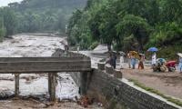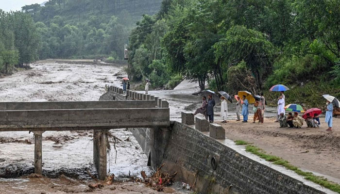
Since June 4, 2025, Pakistan’s northern arc – Gilgit-Baltistan (GB), Azad Jammu and Kashmir (AJK) and Khyber Pakhtunkhwa (KP) districts such as Swat and Buner – has been hammered by cloudbursts and flash floods that have taken hundreds of lives.
These are no longer freak events; they are the new rhythm of a destabilised mountain climate colliding with settlements pushed into harm’s way. Torrents have ripped through valleys, submerging homes, splintering bridges and isolating communities. Kalam in Swat turned into a slurry of boulders and mud; Buner lost access as roads vanished; Hunza and Ghizer – once postcards – now read like ledgers of loss. Cloudbursts dropping a month’s rain in under an hour are overwhelming both natural drainage and the concrete channels we forced upon the land.
Several drivers intensify the damage. Deforestation across watersheds in Swat and Buner has traded root-bound soils for bare, erodible faces. Without vegetation, rain races over ground it once infiltrated, cutting new gullies, loading streams with sediment and destabilising valley walls. In GB’s Diamer and other steep catchments, hillsides have collapsed into rivers, changing courses and pushing risk downstream. Real-estate expansion – often unregulated – has placed homes, hotels and plazas on riverbanks, alluvial fans and floodplains. In Muzaffarabad and Mingora, colonies built on ‘reclaimed’ ground have suffered most because the land was never reclaimed; it was borrowed from the river.
Concrete has replaced sponge-like soils, turning stormwater into a fast, shallow weapon. Mining compounds the hazard: unregulated limestone quarrying in Buner has weakened rain-stressed slopes. The Karakoram Highway, the region’s lifeline, has been blocked repeatedly by landslides triggered by the very erosion our choices accelerate.
We were warned. In January 2010, the Attabad landslide dammed the Hunza River, creating a 21-kilometre lake over 100 meters deep, drowning long stretches of the highway, killing residents, displacing thousands and stranding tens of thousands more. Attabad was a message. Yet within years, portions of its shores were commodified – resorts and farmhouses along a body of water born of catastrophe – accompanied by allegations of untreated sewage meeting ice-blue water. Treating a geologic admonition as a scenic amenity says less about nature than about us.
The toll is measured beyond lives. Farmers in Buner lost whole harvests; tourism-dependent communities in GB face collapse; schools, clinics and bazaars lie ruined; the psychological costs – grief, displacement, groundlessness – are immeasurable. Along the Swat River, where repeated disasters and warnings should have settled the matter, commercial structures again hugged the edge, only to be swept away as the river reclaimed its right-of-way. The pattern is not bounded by a border. In India’s Himachal Pradesh and Uttarakhand, and in Indian-occupied Kashmir, recent seasons follow the same script: extreme, short-duration rainfall stalls over steep catchments; torrents descend along ancient channels; settlements on fans and floodplains are scoured and, in places, turned back into riverbeds. Geography is changing because climate is changing – and because our maps, codes and incentives have not kept up.
Understanding the pattern is survival. Himalayan rivers carry ‘memory’ and alluvial fans are mobile. In quiet years, channels sit within embankments; in wet years, they jump to paleochannels, surge across fans, undercut roads, and tear at bridge abutments. Fans are not terraces but deposits from violent flows, destined to be reworked. Add warmer, moister air, melt pulses, bare slopes and hardscaped towns, and sudden, landscape-scale rearrangements become expected.
Policy must match the land’s logic. Start at the ridge and work down: regenerate native cover, close illegal cuts and use bioengineering to pin soils and restore the mountains’ sponge function. Give planning teeth: enforce no-build and managed-retreat zones on floodplains, fans and river setbacks; create riparian buffers that are more than lines on maps; halt riverbank hotels and plazas in high-hazard corridors. Regulate or stop mining where slopes cannot be stabilised. Relocate or elevate infrastructure out of scour zones; when relocation is impossible, design assumes slope and bridge failure, not permanent stability.
Early warning must be hyperlocal and fast: valley-scale rain and stream gauges, sirens and cell-broadcast alerts that trigger when thresholds are crossed. Build a modern hazard atlas using remote sensing, historic flood imprints and geomorphic mapping to delineate paleochannels, debris-flow paths and fan extents across GB, AJK and KP – and treat those lines as hard constraints on where people live. Mountain towns need sponge-city tools adapted to altitude. Budget community preparedness as infrastructure: mapped evacuations, drills and local brigades equipped for first response.
We cannot pretend every scenic bank or fan is a developable plot, or that yesterday’s benign stream will not be tomorrow’s river. These disasters are political and ecological outcomes – products of incentives to build where it is cheap and scenic, of weak enforcement and of short-term economics over long-term safety.
The floods of 2025 are a wake-up call written in water and stone. If the geography of GB and KP is changing, then policies and priorities must change with it. Resilience is not only rebuilding walls after they fall; it is redrawing our maps to respect the land’s memory and learning to live with the mountains on their terms, not ours.
The writer is an expert on climate change and sustainable development and the founder of the Clifton Urban Forest. He tweets/posts @masoodlohar and can be reached at:mlohar@gmail.com