Print Story
X

The unequal distribution of facilities and amenities is the main reason for the growing urbanisation of Peshawar
The city engulfs its pastoral outskirts
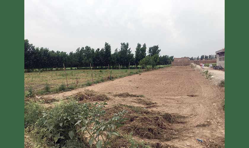
Anwar Gul, 66, resides in what was once the most green area of Peshawar city, on the Ring Road in Pishtakhara village. Before the war in Afghanistan, the Ring Road was an isolated and deserted path; it was known for being dangerous after dusk. At the time, Gul’s family would grow wheat, maize, vegetables and flowers on their farmland. The outskirts of Peshawar could sustain food production for the entire provincial capital. In the aftermath of 9/11, money flooded in, the unsustainable economy was bolstered and the Peshawar Ring Road became one of the busiest roads.
When the Ring Road became a NATO supply-route, dozens of tire shops, hotels, depots, grocery stores, truck stands and banks opened branches along the road. “Gone are the days when we would enjoy the milk and yogurt from our own buffalo and cow,” Gul recalls. “There were fields instead of these unending, concrete and iron buildings,” he points towards the road-side malls and workshops. With this unplanned development, the Peshawar Ring Road attracted real estate entrepreneurs. The road was built in the very heart of the agricultural area. That swas the beginning of converting fertile land into housing schemes.
In the third master plan for Peshawar city development, the authorities had suggested three ring roads, but only one project was completed – at the heavy cost of productive agricultural land. Anwar Gul says the Ring Road divided people’s land. The land on one side of the Ring Road remained agricultural, but people were forced to sell the land on the other side of the road (facing the city), because it was now impossible to irrigate it.
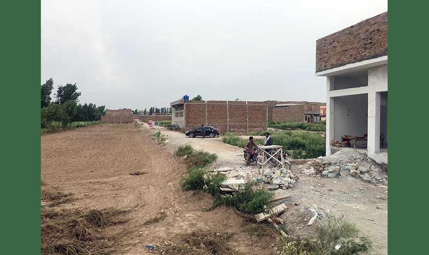
Before the real estate boom, people in this part of the world hadn’t expected to receive such lucrative offers for their land. Many property dealers established their offices in and around the city. Later, the city expanded further and began encroaching upon the remaining fertile land. The trend of cooperative housing societies also began and a majority of the schemes were along the Ring Road. The Defence Housing Authority, and some small colonies are located near the Nasir Bagh area, on the bank of the canal. A vast tract of land, behind Peshawar Intermediate Education Board in Nasir Bagh, is already in the control of real estate companies.
The Ring Road, and the war in Afghanistan, paved the way for entrepreneurs and military organisations to invest in Peshawar, without following the proper procedure. Anwar Gul, and many of his peers, now share tales of better weather and organic food. Gul has also sold his land and now, plazas, education institutions and ill-planned housing schemes have replaced farms and fields. Gul says that the price offered for the land was tempting. “The other issue for farmers like us,” he adds, “was that we were not earning enough and the costs of fertilisers, pesticides were rising rapidly.”
The availability of rich fertile soil and sufficient water for irrigation makes Peshawar district a prime place for agriculture development. The Kabul River and its tributaries provide water for irrigation. The Kabul River enters Peshawar district at Warsak and flows towards east, roughly along the northern border of the district. The Bara River enters the district from the south-west and flows towards the north-east, joining the Kabul River in Nowshera district.
Agriculture Secretary Dr Muhamad Israr says he warned the government about the grave issue of shrinking agricultural land and the mushroom-growth in population and housing societies. “Ensuring food security is the next war for the provincial and federal governments,” Dr Israr says. “Not only in Peshawar, but also in other big cities of the province, fertile land is going under concrete jungles. This is alarming.”
He says that Peshawar, the provincial capital, is under pressure because of an influx of immigrants from less developed towns. The population is becoming uncontrollable for both rural and urban departments. The government should encourage vertical construction to protect agricultural land, he suggests.
According to the Peshawar Development Authority’s (PDA) 1965-85 master plan, construction is forbidden on the most fertile agricultural land, surrounding Warsak Dam. It is unfortunate that the same PDA has flouted its own recommendation by initiating the Regi Lalma Housing Scheme project. The project has devoured a huge chunk of agricultural land. Beside some small ones, there are two other massive housing societies of the military, Askari and Defense Housing Authority (DHA), planned over agricultural land near Warsak. Sources privy to the matters say the DHA made Rs 12 billion, in the early days, without selling an inch of land. Thousands of people have applied for costly application forms. The charge is non-refundable.
Throughout the world, ring roads are built for easy and accessible transport to and from far flung areas. There has to be a green belt of at least 200 feet on both sides of such roads to discourage business activities. But the development of Peshawar Ring Road, and some other roads in the country, violates the convention. Property owners and real estate investors and tycoons bought fertile land located on the sides of the Ring Road and then converted it into shopping centres, housing societies, malls and plazas. In Peshawar, the land on both sides of any road is very expensive and always in demand.
The population is growing, while farm land is shrinking and this is a big threat to food security.
Population
distribution and growth
In the case of Peshawar district, the population growth rate increased from 1951 to 1981, but declined during 1981-1998. It was 3.89 percent in 1972-1981 and fell to 3.56 percent between 1981 and 1998. The growth rate is currently increasing, it was 3.99 percent from 1998 to 2017. The district’s population growth rate has been significantly higher than the provincial growth rate during the same period.
Khyber Pakhtunkhwa has a 2,200 kilometre border with Afghanistan. After the Russian invasion, millions of Afghan citizens took refuge in Pakistan’s western towns. Many refugee camps were established in and around Peshawar city. This sudden flow of refugees made the city more cramped. New buildings come up, first on the very busy University Road.
Urban Planning Director Adnan Saleem is worried about the rapid population and infrastructure growth in Peshawar district. He says that unplanned migration and natural population growth can put a heavy burden on any society. The population growth rate in Pakistan is 2.4 percent but in KP it is 2.8. “In rural areas the average is 3 percent, which is alarming,” Saleem says. He says once the fertility average reaches 2.5, it means that the population will double in 20 years.
Lack of education, healthcare, security and entertainment in the rest of province attracts people to the urban side of KP, Adnan Saleem explains. For decades, students from the rest of the province have come to Peshawar for higher education. The government has to build modern facilities in other districts to stop urbanisation, he warns.
Out-of-the-box solutions
Dr Sami Ullah is an assistant professor at the Geography Department, University of Peshawar. His PhD thesis was titled Expansion of built-up area and its impact on urban agriculture: a case study of Peshawar. Dr Sami Ullah argues that the state should ensure the provision of security, education, employment opportunities, healthcare and municipal services to people living in rural settings. He believes that unplanned construction has not only ruined agriculture, but also affected the climate and the environment. Two factors drive urbanisation: the city attracts people by providing healthcare, education, rule of law, infrastructure and job opportunities to its inhabitants, while the villages push the people towards urban settlements with their lack of these facilities.
Dr Sami Ullah suggests that there should be a balance in the facilities for the local population, with respect to urban and rural areas. Providing modern facilities in less developed cities will definitely control urbanisation, he says. The biggest issue for Pakistani cities, he says, is their drastic crowding both in terms of the human population and apartments, homes, plazas, markets and housing societies. “The KP and even the federal government can control the ill-planned urbanisation by providing facilities and making the intermediary towns more attractive,” Dr Sami Ullah says. “People try their luck in Charsadda, Mardan, Bannu and Kohat etc, but once they come to know about bigger opportunities in big cities, they migrate to Peshawar.”
During the British colonial rule, the cantonment area of Peshawar was far bigger than Peshawar city. The unequal distribution of facilities and amenities is the main reason for the growing urbanisation of Peshawar. Since Peshawar is the provincial capital, all the headquarters are based in this overpopulated city. Every day, thousands of people come for all kinds of activities to Peshawar. Since Peshawar is in the middle of the province, and also has the shortest route to Afghanistan and Central Asian states, its commercial importance never decreased.
According to Dr Sami Ullah, “A master plan was developed for Peshawar in 1965, covering the period 1965-85 to streamline the growth of the city. Among others, the plan indicated the new potential growth boundary of the city, as did the Structure Plan of 1986. Unfortunately, neither of these plans was approved or implemented and unplanned growth continued particularly along the radial roads leading out of the city.” The 1965-85 plan was not implemented because it was not approved by the concerned authorities, although the government had spent a large amount on developing this master plan. Rs 16 million was spent on the structure plan but it was also not approved by the cabinet. In 2006, the plan was updated but, so far, no government has tried to implement it.
The structure plan proposes that there should be no development in north Peshawar as the region is best suited for agriculture and situated in a flood zone. The region comprises Regi, Warsak Road, Charsadda Road and Tarnab. Dr Sami says that when the population was smaller and there was less construction, flash flood water would drain into the river unimpeded. “However, the locals constructed buildings over the streams. Now the water doesn’t have a proper path. It also doesn’t get absorbed very quickly because of the high water table. Ultimately floods devastate everything that comes in their way.” In the 2010 flood, the water destroyed many houses built on and around the old streams.
The north-east end of DHA, located near Shahi Bala on Warsak, is also in the prohibited zone. Beside this, there are dozens of smaller housing societies. Natural streams have been disrupted by this construction, which will inevitably make these expensive societies vulnerable to flood damage.
Hayatabad and Regi Lalma were not in the master plan when the PDA violated its own recommendations and constructed unplanned buildings. But since the plans were never approved, nobody could not be charged with a violation. We have lost precious agricultural land because to rapid construction. None of the current or past governments has imposed a ban on construction on the most fertile agricultural land in the north of Peshawar.
The impact of unplanned urbanisation
Ultimately, after losing the fertile land, we are now witnessing skyrocketing prices of food and the unavailability of local produce. The government should compel the PDA to work effectively and stop further construction on agricultural land. The population is growing, while agricultural land is shrinking. This is a big threat to food security.
Furthermore, the land of the Peshawar valley (Peshawar, Mardan, Charsadda, Nowshera and Swabi) is the most fertile in the province. It is crucial to safeguard the food basket of the province. Congested growth also spreads waterborne diseases and pollutes groundwater. Eventually, people either migrate from such places or figure out new ways to get safe drinking water. The decentralisation of facilities is the ultimate solution to this very dangerous trend, according to Dr Sami Ullah. While the Ring Road has decreased the traffic burden on the main city, we have set up commercial centres, hotels and housing societies on these roads.
Malang Kaka, who lives near Pajjagi Road on the north side of Peshawar, says that he was dependent on farming for his family’s livelihood. “We are worried now, we don’t have agricultural land any longer and we have to buy all our food from the market. With the passage of time, we have started to buy wheat in bulk to store it at home. Now our kitchen expenditures are out of control and we are worried about our future.” Kaka says that he now works for a private organisation as a security guard. In the past, he would work in the fields and would also lease and cultivate farmland to feed his family.
Since the land owners have been selling their land, to be used for unplanned housing societies and plazas, the region is now unable to provide sufficient food to its residents. In recent days, the price of a roti has reached 15 rupees in Peshawar. The prices of vegetables are also rising. In the name of development, the region has been transformed from a green forest to a concrete jungle.
The writer is a Peshawarbased freelance journalist. He tweets @theraufkhan