Print Story
X

Unchecked settlements on the katcha lands along River Indus in Sindh is the main cause of human and material damage
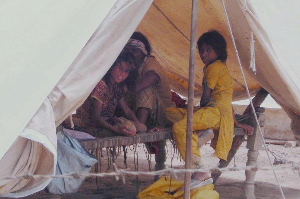
While sitting in a makeshift shed by the roadside, Qutubuddin Khoso hopes the floodwater recedes soon and he is able to go back to his small village, located in the katcha area of River Indus in Ghotki district, Sindh. "Several villages in my area got inundated with floodwater but no one from the government reached out to us. We were able to come out of the village but so many more people are stranded there," he says.
The swollen River Indus has forced many locals to leave their homes situated in submerging katcha areas. The floods, considered by experts to be a manifestation of climate change, are pushing the already poor, landless, daily wage peasants further into poverty. They work mostly on lands of influential feudal lords.
According to the official handout issued by the Sindh CM House on Tuesday, more than 425,000 people have been displaced in Sindh, out of them around 375,000 people are residents of katcha area in three districts including Sukkur, Khairpur and Ghotki. Some 350,000 acres of standing crops have been washed away, 7,272 houses damaged and 218 animals have died due to the flood.
Though the flood has affected people in katcha area of other districts in Sindh too, the provincial government is more focused on the worst-hit districts presently. It has established only 38 official relief camps in three districts where only 43,431 people have taken shelter. The remaining 377,000 people are living without the government’s support and relief. A majority of them are left high and dry under the open skies.
Even a cursory glance at the area brings back the horrid scenes of the 2010 floods. The same promises of rescue, relief and rehabilitation are reverberating around the area. People from the katcha areas are rushing to safer places, stranded ones are rescued in motorboats, those that cannot be rescued are provided ration through army helicopters. Provincial Disaster Management Authority (PDMA) Sindh and different non-governmental organisations (NGOs) have announced the start of relief operations in the flood-hit areas. And, Prime Minister Nawaz Sharif has visited the flood-hit areas in the northern Sindh and announced a Rs1 billion relief package.
Pakistan in general has become vulnerable to climate-related disasters and within Pakistan Sindh is most at risk. Sindh suffered severe flooding in 2010, 2011, 2012, severe drought in 2013 and 2014, and this year, in 2015, so far, the heatwave has killed more than 1,300 people in the provincial capital of Karachi alone.
After the 2010 floods, the Indus River Commission, a top-level body of the irrigation department, approved 10 different projects to strengthen the River Indus embankments and canals in order to protect the surrounding areas from flooding. Almost five years on, work on none of these approved projects has started, perhaps because "floods are normal in Sindh. It is the government’s incompetence that turns even average rains into flood and hence disaster," says a former official of the Sindh Irrigation department.
The annual River Indus floods have historically been the most important natural event that brings fertile silt which is very important for the soil fertility. Water experts believe floods are important for the survival of river because by flooding, the river keeps paths of its flow clear.
Though River Indus is passing through the entire country, it becomes fatal when it reaches human settlements in the katcha areas of Sindh. Besides having hundreds of villages, katcha areas on either sides of the river are used for agriculture. The katcha area is the fertile land located between the protective embankments that exist on either sides of River Indus and the width between both embankments is from one kilometre to several kilometres.
Therefore, every year when annual floods reach katcha areas, it irrigates the fertile lands of the katcha.
"The existence of human settlements in katcha areas, which is actually riverbed, is illegal. If the provincial government evacuate these settlements from the katcha area on permanent basis, floods will not be as fatal as they are," an official of the Sindh Forest Department told TNS on conditions of anonymity.
Most of the katcha lands are occupied by influential feudal lords for agriculture purposes for which they need workers/farmers. These farmers build their settlements on the katcha land. Despite being located on the riverbed, some of these settlements are huge -- with government schools, basic health units and even police posts. When there are more than normal rains, these settlements submerge with floodwater.
Though some of these lands are illegally occupied by influential landlords, the Sindh government has also allotted large areas to small farmers for agricultural purposes.
"Katcha land is allotted to small growers for the restoration of riverine forests under the Sindh Agro-forestry lease policy. Under this policy, a piece of land comprising 40 acres is allotted to a farmer with a condition that he will use 75 per cent or 30 acres for agriculture purpose and will grow forest on 25 per cent or 10 acres of that land," forester Gobind Menghwar told TNS.
He confirms that most of the people who are allotted the land do not follow the rules and use the entire land for agriculture.
At many places inside the katcha area, powerful feudal lords have constructed their own protective embankments inside the riverbed to protect their agricultural lands and crops from floods. "These embankments hinder the flow of floodwater coming from KPK and Punjab. The floodwater takes several more days to reach the Arabian Sea," says renowned water expert and former secretary Irrigation Sindh, Idrees Rajput.