Print Story
X

Computerisation of land record has made life easier for the people in KPK
The Pakistan Tehreek-e-Insaf-led Khyber Pakhtunkhwa government has announced the successful completion of the first phase of the computerisation of the land record in Mardan division as part of an exercise to extend the facility to 19 out of the 25 districts of the province.
Officials concerned said the scanning of the record and data entry was going at a swift pace in six other divisional headquarters. Swat has been excluded from the project due to militancy.
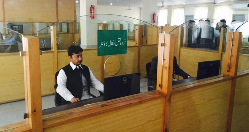
The record on the Register Haqdarane Zamin (RHZ or periodical record of rights) and intiqal (mutation) of all 176 mauza (villages) in Mardan has been computerised. The Service Delivery Centre (SDC) in Mardan provides various services about land assets. The building is air-conditioned and its entrance has stairs and ramps for the disabled along with toilets, separate waiting areas for gents and ladies, service counters and display of guidelines including tax rates and service charges.
Noor Khan, in-charge of the SDC Mardan, told TNS that the centre was providing clients with a number of services such as the issuance of Fard Malkiat (record of rights), mutation, and stamps.
He said that tokens are issued according to the type of request by the customers. "The client’s name, father’s name, CNIC number, address, contact number and the service requested is mentioned on the token," he said.
Although the service became active recently, it has already made things easier and quicker for the people. "A person used to get Fard after weeks or even months under the previous manual system. Now they can get it on the spot within 10 minutes," Noor Khan claimed.
The mutation process that used to take months under the manual system has also been made easy for buyers and sellers. "A client provides the required data to the mutation counter. He is then issued the fee slip for the transfer and is asked to visit the centre after seven days as per legal requirement. When the seller, buyer and two witnesses revisit us, we scan their CNICs and fingerprints biometrically and take their photos," he added.
This helps in minimising human errors and tampering. It also speeds up the updating of the periodical record of right or RHZ, which under the patwari system took place after every four years.
Patwaris, the revenue department officials, are the most powerful government officers despite their low grade. They keep and amend all land revenue related record of the state. However, the practice remained prone to accidental and purposeful errors and manipulation, resulting in decades-long disputes that every now and then lead to blood feuds.
Two main problems arising during mutation were the teaming up of the seller of property and the staff to falsely increase the size of the land for sale. The other problem was the impersonation of the real owner with fake identity cards and credentials to sell properties.
The biometric system is geared to counter these issues as the data would be verifiable in real time with NADRA. The data entered at any SDC in the province would be stored at the database at that centre with a mirror image and backups at the district management unit and the provincial headquarters.
Any modification in data at any location can be precisely traced to its origin. The staff at the SDCs will login to their computers with biometric verification of their fingerprints.
Senior Member Board of Revenue (SMBR) Waqar Ayub told TNS that data entry during the computerisation process was done on the same format as in the manual system. "While entering data of shareholders, each individual’s share and volume of land is entered separately," he said.
The other change in data entry is bringing down of the smallest measurement unit, known askaram and measuring 5.5 feet. Previously, a piece of land less than 2 foot-steps was ignored in measuring the land. The new system would improve accuracy as it brings down the measurement to one foot.
WaqarAyub added that on an average it would take four years to computerise each district of the province. "The government asked us to computerise one tehsil in a year. However, we managed to do all of Mardan district in one year. The periodical record of rights in Mardan has been done 100 per cent while the mutation data would be completed by June 2014," he said.
In the pilot activity, the software was developed for storing the all-important record of rights document. The hitches faced in keeping the record’s integrity were eliminated in the first phase.
Currently, the computerisation process of the mauza-wise scanning of periodical record of rights and data entry is in progress in Abbottabad, Bannu, Buner, Dera Ismail Khan, Kohat and Peshawar districts.
After Mardan, Peshawar will soon become the second district with up and running SDCs as the scanning of the periodical record of rights of all its 193 mauza has been completed while mutation of only eight mauza remains to be done. The data entry for 191 mauza had been achieved till date.
The data entry of 1,232 out of 1,657 mauza of the above mentioned seven districts has already been completed while it was in process in 41 mauza.
The computerisation of the land record in 12 other districts of the province will start at a later stage. However, the aim is to have all the record online by 2017.
SMBR Waqar Ayub added that there were added benefits of the computerisation of land record. "In case of partition of land assets, owners can get the statement of ownership from SDC without any trouble. The system will also be able to generate e-stamps in future," he said. "No flaws were reported yet and the experts were assessing the system for further improvements," he added.
The electronic system will replace the patwari system. The patwaris, a powerful figure in the revenue department, would surrender all the record books to SDCs. However, as the patwaris had other responsibilities that might need access to the periodical record of rights, the SDC would issue them duplicate copies of the required documents on demand.
The Board of Revenue is planning to do the cadastral mapping of the real property boundaries using the geographical information system (GIS) in the second phase of updating the land record.
According to Waqar Ayub, the federal government is responsible for conducting the geographical survey in the country under the Surveying and Mapping Act 2013. "The province has gained authority over surveying and the Board of Revenue is now allowed to do survey for 19 districts of KP," he said.
He added that instead of using the rudimentary equipment, the Board of Revenue was adopting Differential Global Positioning Tools for accurate mapping. "We will do Geo Referencing Survey to counter overlapping, distortion and deficiencies. Only 15 per cent of the land cannot be mapped due to land disputes," he added.